Jinlong Ma
New member
Dear users of wrf
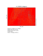
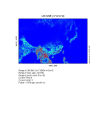
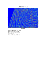
I wanted to use the new landuse to replace the default one in order to stimulate the metrology of the domain in China. The grid size is 200x130 in WRF and 197x127 in CMAQ. I used modis-mcd12 2016 landuse data to change the default setting in WPS, but it didn't work well. The picture below are the landuse_index,lai12m and landmask in geo_em.d01.nc file, I didn't know what happened to it.


Several steps I took to modify the landuse type in WPS. I will list them below.
First, I downloaded the modis-mcd12 landuse data from the NASA website and then used ArcGIS to process the data.
Second, I used GDAL to change the ASCII file into binary format and modified the file name 00001-xxxxx.00001-xxxxx.
Third, I wrote a index file and added arguments (landmask_water= mcd12q1:17, interp_option = mcd12q1:nearest_neighbor,rel_path = mcd12q1:test_modis/). After that, I modified arguments in the namelist.wps.
I will attach these files mentioned above to this post.
I guess there is a problem in my landuse binary file, but I don't know how to figure out it.
I will appreciate it a lot for your advice.
I wanted to use the new landuse to replace the default one in order to stimulate the metrology of the domain in China. The grid size is 200x130 in WRF and 197x127 in CMAQ. I used modis-mcd12 2016 landuse data to change the default setting in WPS, but it didn't work well. The picture below are the landuse_index,lai12m and landmask in geo_em.d01.nc file, I didn't know what happened to it.


Several steps I took to modify the landuse type in WPS. I will list them below.
First, I downloaded the modis-mcd12 landuse data from the NASA website and then used ArcGIS to process the data.
Second, I used GDAL to change the ASCII file into binary format and modified the file name 00001-xxxxx.00001-xxxxx.
Third, I wrote a index file and added arguments (landmask_water= mcd12q1:17, interp_option = mcd12q1:nearest_neighbor,rel_path = mcd12q1:test_modis/). After that, I modified arguments in the namelist.wps.
I will attach these files mentioned above to this post.
I guess there is a problem in my landuse binary file, but I don't know how to figure out it.
I will appreciate it a lot for your advice.
