Scheduled Downtime
On Friday 21 April 2023 @ 5pm MT, this website will be down for maintenance and expected to return online the morning of 24 April 2023 at the latest

Dubious Sahara Desert Lakes

This post was from a previous version of the WRF&MPAS-A Support Forum. New replies have been disabled and if you have follow up questions related to this post, then please start a new thread from the forum home page.

davidsuculum

New member
Hello,

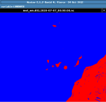
In the geogrid of the WRF 4.1.4, when selecting "modis_landuse_20class_30s_with_lakes" we have observed lots of lakes in the surroundings of the Sahara desert, which we consider dubious. We attach an image and the namelist.wps. Please, note that we used a static dataset that had 3-4 months at the moment of writing this.

In an older WRF version (WRF 3.6) we used static data that didn't have those lakes.

Thanks.
 

Attachments

  • namelist_wps.txt
    1.3 KB · Views: 55
  • dubious_lakes.png
    dubious_lakes.png
    7.8 KB · Views: 1,006
We are aware of the noisy structure of landuse type in MODIS-30s data. Please use the MODIS_15s static input data.
 
Hello. Thank you. I executed again the geogrid for WRF 4.1.4 (the version I am using) with the static data of WRF 4.2 (unfortunately, I no longer have the original static data of WRF 4.1.4). I used for MODIS the 15s but I am afraid that the problem, at least in our area, near the Sahara desert, remains.
 
Wouldn't these "lakes" be created because some of the zones are below sea level and automatically "filled" by the software?
 
I am able to repeat this case and get the same results. I am not sure whether these lakes in the desert truly exist, or they are caused by errors in the dataset. I talked to our expert who knows well the land module, but he also has no idea of lakes in Sahara. I am sorry that I cannot help in this issue.
 
Top