Scheduled Downtime
On Friday 21 April 2023 @ 5pm MT, this website will be down for maintenance and expected to return online the morning of 24 April 2023 at the latest

about the land use and urban heat island

This post was from a previous version of the WRF&MPAS-A Support Forum. New replies have been disabled and if you have follow up questions related to this post, then please start a new thread from the forum home page.

Hi,
I replaced the urban land types with cropland and turned off anthropogenic heat,but why is the temperature in the original urban area still higher than that in the surrounding area? I see that the urban heat island will disappear after these operations in some papers. Is there any other setting needed?
 

Attachments

  • T2.jpg
    T2.jpg
    39.4 KB · Views: 1,629
Hi,
1) At which stage of the WPS or WRF process did you modify the land type? Did you modify the geo_em* files, or perhaps later after running real.exe?
2) Is the temperature plot identical to the plot prior to modifying land type, or are you seeing a difference? If so, how do they compare?
3) Will you also attach your namelist.input file so that I can take a look? Thanks!
 
kwerner said:
Hi,
1) At which stage of the WPS or WRF process did you modify the land type? Did you modify the geo_em* files, or perhaps later after running real.exe?
2) Is the temperature plot identical to the plot prior to modifying land type, or are you seeing a difference? If so, how do they compare?
3) Will you also attach your namelist.input file so that I can take a look? Thanks!
Hi,thanks for your reply.
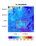
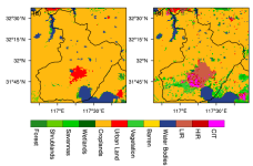
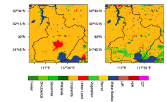
(1)I modify land type in the geo_em* files.
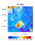
(2)I attached the plot where the land type is not modified.The temperature in the urban is higher compare to that before modification.
(3)here is my namelist.input:
&time_control
run_days = 41,
run_hours = 00,
run_minutes = 0,
run_seconds = 0,
start_year = 2019, 2019, 2019,
start_month = 06, 06, 06,
start_day = 23, 23, 23,
start_hour = 00, 00, 00,
end_year = 2019, 2019, 2019,
end_month = 08, 08, 08,
end_day = 03, 03, 03,
end_hour = 00, 00, 00,
interval_seconds = 21600
input_from_file = .true.,.true.,.true.,
history_interval = 180, 180, 60,
frames_per_outfile = 8, 8, 24,
restart = .false.,
restart_interval = 7200,
io_form_history = 2
io_form_restart = 2
io_form_input = 2
io_form_boundary = 2
history_outname = './summer2019_NOURBAN/wrfout_d<domain>_<date>',
/

&domains
time_step = 150,
time_step_fract_num = 0,
time_step_fract_den = 1,
max_dom = 3,
e_we = 60, 101, 126,
e_sn = 60, 101, 126,
e_vert = 35, 35, 35,
p_top_requested = 5000,
num_metgrid_levels = 34,
num_metgrid_soil_levels = 4,
dx = 25000, 5000, 1000,
dy = 25000, 5000, 1000,
grid_id = 1, 2, 3,
parent_id = 0, 1, 2,
i_parent_start = 1, 10, 40,
j_parent_start = 1, 28, 48,
parent_grid_ratio = 1, 5, 5,
parent_time_step_ratio = 1, 5, 5,
feedback = 1,
smooth_option = 0
/

&physics
physics_suite = 'CONUS'
mp_physics = 6, 6, 6,
cu_physics = 1, 1, 1,
ra_lw_physics = 1, 1, 1,
ra_sw_physics = 1, 1, 1,
bl_pbl_physics = 1, 1, 1,
sf_sfclay_physics = 1, 1, 1,
sf_surface_physics = 2, 2, 2,
radt = 25, 25, 25,
bldt = 0, 0, 0,
cudt = 5, 5, 5,
icloud = 1,
num_land_cat = 33,
sf_urban_physics = 0, 0, 0,
/

&fdda
/

&dynamics
hybrid_opt = 2,
w_damping = 0,
diff_opt = 1, 1, 1,
km_opt = 4, 4, 4,
diff_6th_opt = 0, 0, 0,
diff_6th_factor = 0.12, 0.12, 0.12,
base_temp = 290.
damp_opt = 3,
zdamp = 5000., 5000., 5000.,
dampcoef = 0.2, 0.2, 0.2
khdif = 0, 0, 0,
kvdif = 0, 0, 0,
non_hydrostatic = .true., .true., .true.,
moist_adv_opt = 1, 1, 1,
scalar_adv_opt = 1, 1, 1,
gwd_opt = 1,
/

&bdy_control
spec_bdy_width = 5,
specified = .true.
/

&grib2
/

&namelist_quilt
nio_tasks_per_group = 0,
nio_groups = 1,
/
 

Attachments

  • T2_CTRL.png
    T2_CTRL.png
    55.7 KB · Views: 1,621
Hi,
Thanks for sending those. What are the surrounding landuse types outside the urban area? Do you happen to have a landuse plot you can send, that shows the types in the key?
 
kwerner said:
Hi,
Thanks for sending those. What are the surrounding landuse types outside the urban area? Do you happen to have a landuse plot you can send, that shows the types in the key?

It's cropland.The land type before modification is shown in Fig(b).
And I noticed that the greenfrac,lai and albedo are smaller in urban area,maybe that's why it's still warmer in urban areas.But for these variables I don't know how to modify,and only the land type was changed in some papers I've read.
 

Attachments

  • land_cover.png
    land_cover.png
    54 KB · Views: 1,611
Hi,
In the landuse plots you sent, you're saying that figure (a) shows the new landuse (after you modified it), correct? While figure (b) shows the original? If that's the case, it still looks like there is a large area of urban land (red) in the area where you modified, which would explain the heat island effects you're seeing.
 
kwerner said:
Hi,
In the landuse plots you sent, you're saying that figure (a) shows the new landuse (after you modified it), correct? While figure (b) shows the original? If that's the case, it still looks like there is a large area of urban land (red) in the area where you modified, which would explain the heat island effects you're seeing.

Hi,the plot(a)shows the default land cover in WRF,and plot(b) shows the updated land cover and the urban area is larger,and the plot that I replace urban land with cropland is not put here.
 
kwerner said:
I see. Do you mind posting the plot of the one with your modification? Thanks!
The right figure is the one that replacing urban land type with cropland.
 

Attachments

  • crop.png
    crop.png
    53.1 KB · Views: 1,578
Hi,
Thank you for sending that, and I apologize for the delay in response. I believe the reason for the warmer area, even after removal of urban land type could be a few different factors. First, I notice in the modified/urban-removed plot, there is now a lot more vegetative areas surrounding the now crop land, which could lead to evaporative cooling in those locations, but not where the large open space of crop land is. The crop land is also not obstructed from downward radiation, so it has the chance to warm more during the days, as opposed to surrounding areas, which may have more shading. I'm not sure what the elevation is like in this area, or the primary direction of wind, but perhaps those could make a difference, as well. I think the fact that you are definitely seeing a vast difference between the original run (with urban) and with the modified landuse means that the model is definitely detecting that change and the simulation is based on it.
 
Top