Yichen Yang
New member
Hi I'm a WRF starter and would like to test unified Noah LSM with the landscape mosaic feature. My AOI is the New Haven County, Connecticut, US, which is an urbanized area. I simulated for a couple of days (July 05-08, 2020) and checked the time series of Sensible Heat, Latent Heat and the Ground Heat Flux, which should add up to be approximately the net radiation.

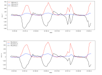
However, the Ground Heat flux of 2 selected urban grids are way too high than I expected. The mid-noon GRDFLX is usually higher than 300 W m^-2 as you can see from the black lines in the figure. In addition, the blue lines and the red lines are the Latent Heat and the Sensible Heat, respectively. The top panel and the bottom panel are for the grids named Hillhouse and Yale Bowl, respectively. They are both urban.
The results look a bit strange to me because the previous studies rarely showed a magnitude of GRDFLX higher than 200 W m^-2. Dan Li's paper introducing the mosaic approach showed that GRDFLX is lower than 150 W m^-2 for a medium-level urban site. (https://agupubs.onlinelibrary.wiley.com/doi/epdf/10.1002/2013JD020657)
The overarching goal of my WRF practice is to see whether Noah LSM + mosaic approach without the UCM coupled can model the Urban Heat Island effectively. In my namelist.input, I set mosaic_cat = 3, indicating that only the top 3 landuse categories will be considered in the coarser grids. The NLCD2011_9s data was used to represent the landscape. All the work was completed on the Cheyenne Cluster.
I have a couple of quick questions as followed.
1. Has anyone got similar GRDFLX results to me? What would be the reason for this unreasonable magnitude?
2. As a Cheyenne user, the landuse data are usually provided from ~wrfhelp/SOURCE_CODE. However, the NLCD data should be originally of 30-m resolution while the nlcd2011 in Cheyenne is at most of 9s resolution (~300 m). Was that aggregated to a coarser resolution for some purpose?
I also attached my namelist.input to have someone experienced to check my basic settings. Would be grateful if you guys could point out any problem in the file.
View attachment namelist.input
Thanks!
Yichen
