I deeply appreciate all of the WRF developers for their great effort.
Now I am trying to conduct high-resolution simulation (25km/5km/1km/0.2km).
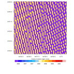
When I checked the output of geogrid.exe for 0.2km domain, I found the rotation angle (COSALPHA and SINALPHA) is quite noisy
(see: cosalpha_dx200m_original.png).
I have checked the source code, and found that the difference of latitude and longitude, which is used for the calculation of rotation angle in process_tile_module.F, is close to the minimum value of single precision float for the high-resolution domain.
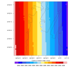
I found that it can be fixed if I have conducted double-precision calculation for geogrid.exe, and I also found that rotation angle calculation with 'cone', which is applied in 'wrf_fddaobs_in.F', is useful even for single-precision calculation (see: cosalpha_dx200m_modified.png).
I would like to know if there is a problem in my procedure.
Now I am trying to conduct high-resolution simulation (25km/5km/1km/0.2km).
When I checked the output of geogrid.exe for 0.2km domain, I found the rotation angle (COSALPHA and SINALPHA) is quite noisy
(see: cosalpha_dx200m_original.png).
I have checked the source code, and found that the difference of latitude and longitude, which is used for the calculation of rotation angle in process_tile_module.F, is close to the minimum value of single precision float for the high-resolution domain.
I found that it can be fixed if I have conducted double-precision calculation for geogrid.exe, and I also found that rotation angle calculation with 'cone', which is applied in 'wrf_fddaobs_in.F', is useful even for single-precision calculation (see: cosalpha_dx200m_modified.png).
I would like to know if there is a problem in my procedure.