Dear WRF support team,
I have been working with the official SLUCM anthropogenic heat emission (AHE) dataset provided on the WRF geographic data download page:Static Data Downloads

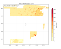
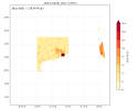
However, I encountered a puzzling issue: the AHE data appears to be severely displaced in the resulting geo_em.d01.nc file. I have tested this in two separate domain configurations centered over: Chongqing, China and Hong Kong SAR
In both cases, the AHE field shows obvious misalignment — data tiles appear to be misplaced or "jumped" to incorrect locations far from the target region. No other geographic variables (e.g., LU_INDEX, ALBEDO) show such misalignment — only AHE.
Please refer to the figures below:


Is this a known issue with the official SLUCM AHE dataset (e.g., tile misalignment or indexing error)?Or is it possible that I made a mistake in my setup or usage?
I would greatly appreciate any clarification or suggestions. Thank you!
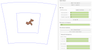
PS: namelist.wps settings in Chongqing: (Figure in QGIS with the following setting)
```namelist
&geogrid
parent_id = 1, 1, 2,
parent_grid_ratio = 1, 3, 3,
i_parent_start = 1, 81, 201,
j_parent_start = 1, 81, 201,
e_we = 307, 439, 79,
e_sn = 311, 451, 121,
dx = 9000.0,
dy = 9000.0,
map_proj = 'lambert',
ref_lon = 106.79891570499628,
ref_lat = 29.73164201861055,
truelat1 = 30.0,
truelat2 = 60.0,
stand_lon = 105.0,
geog_data_res = 'y2010_urb+y2010_ahe+cglc_modis_lcz+default',
/
```

I have been working with the official SLUCM anthropogenic heat emission (AHE) dataset provided on the WRF geographic data download page:Static Data Downloads

However, I encountered a puzzling issue: the AHE data appears to be severely displaced in the resulting geo_em.d01.nc file. I have tested this in two separate domain configurations centered over: Chongqing, China and Hong Kong SAR
In both cases, the AHE field shows obvious misalignment — data tiles appear to be misplaced or "jumped" to incorrect locations far from the target region. No other geographic variables (e.g., LU_INDEX, ALBEDO) show such misalignment — only AHE.
Please refer to the figures below:


Is this a known issue with the official SLUCM AHE dataset (e.g., tile misalignment or indexing error)?Or is it possible that I made a mistake in my setup or usage?
I would greatly appreciate any clarification or suggestions. Thank you!
PS: namelist.wps settings in Chongqing: (Figure in QGIS with the following setting)
```namelist
&geogrid
parent_id = 1, 1, 2,
parent_grid_ratio = 1, 3, 3,
i_parent_start = 1, 81, 201,
j_parent_start = 1, 81, 201,
e_we = 307, 439, 79,
e_sn = 311, 451, 121,
dx = 9000.0,
dy = 9000.0,
map_proj = 'lambert',
ref_lon = 106.79891570499628,
ref_lat = 29.73164201861055,
truelat1 = 30.0,
truelat2 = 60.0,
stand_lon = 105.0,
geog_data_res = 'y2010_urb+y2010_ahe+cglc_modis_lcz+default',
/
```

