Scheduled Downtime
On Friday 21 April 2023 @ 5pm MT, this website will be down for maintenance and expected to return online the morning of 24 April 2023 at the latest

CRITICAL ERROR: NaN detected in 'w' field

jpen

New member
I am using variable (60-km - 3-km) mesh "x20.835586.grid.nc" and using grid_rotate changed the center over South America. However, atmosphere_model crashes with
CRITICAL ERROR: NaN detected in 'w' field
I have set
&nhyd_model
config_time_integration_order = 2
config_dt = 18.0 also with [15.0 / 10.0 / 24.0 / 50.0 ]
&printout
config_print_global_minmax_vel = true
config_print_detailed_minmax_vel = true

How to resolve this error?
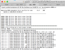
 
Can you attach your namelist.atmosphere and log.atmosphere.0000.out files? What dataset are you using for initial conditions?
 
Hi Michael, Thank you! I have accidentally deleted the log.atmosphere.out file but I am attaching the namelist file. I remember, the atmosphere_model run creates diag and history files for the initial timestep and then crashes. I will rerun again to obtain log.atmosphere.out.
For ICs. I used ds083.3 dataset available from rda.ucar.edu and processed it using WPS. For static fields, I used the database given in MPAS tutorial https://www2.mmm.ucar.edu/projects/mpas/tutorial/Boulder2019/input_data/mpas_tutorial.tar.gz.
 

Attachments

  • namelist.atmosphere.log
    1.8 KB · Views: 3
Thanks for attaching your namelist! I think you'll need to set
config_len_disp = 3000.0
in your namelist.atmosphere file, since config_len_disp is assumed to be the minimum horizontal grid distance in the mesh. Specifying a larger value for this parameter can lead to instability, which is what you might be encountering.
 
I changed it to 3000.0 yet the error remains. Please see the attached log and namelist files.
 

Attachments

  • namelist.atmosphere.log
    1.8 KB · Views: 1
  • log.atmosphere.0000.out.txt
    16.2 KB · Views: 3
From your namelist.atmosphere file, you're using a time step of 32 seconds. Typical guidance is to use a timestep around 5 or 6 times the minimum grid distance in km. Could you try a 15 s timestep?
 
I tried a 15 s timestep an it crashed after simulating one day. Attached are the atmosphere log and screenshot of error message with files written. It could not write the restart file. My guess is that io_type="pnetcdf,cdf5" should be included for restart as well in the streams.atmosphere!
 

Attachments

  • log.atmosphere.0000.out.txt
    5.1 MB · Views: 5
  • Screen Shot 2023-03-23 at 6.06.19 AM.png
    Screen Shot 2023-03-23 at 6.06.19 AM.png
    206.5 KB · Views: 8
  • streams.atmosphere.txt
    1.6 KB · Views: 5
It was right. Thanks again!
One more question - Since running global simulation is computationally expensive, is it appropriate to define a desired region for limited area simulation using the variable resolution input (x20.835586.static.nc)? The desired region lies in the refined region of the variable resolution mesh. Or do I need to use 3-km quasi uniform mesh? Also, is the database from mpas tutorial good enough for generating static fields and initial data from ds083.3 for generating ICs at 3 km?
 
Last edited:
It was right. Thanks again!
One more question - Since running global simulation is computationally expensive, is it appropriate to define a desired region for limited area simulation using the variable resolution input (x20.835586.static.nc)? The desired region lies in the refined region of the variable resolution mesh. Or do I need to use 3-km quasi uniform mesh? Also, is the database from mpas tutorial good enough for generating static fields and initial data from ds083.3 for generating ICs at 3 km?
It's good to hear that setting io_type="pnetcdf,cdf5" for the "restart" stream resolved the I/O issues. Since your follow-up questions aren't related to the original topic of this discussion, and since we'd like to try to keep topics more focused so that they're hopefully easier to browse, would you mind creating a separate thread to discussion your questions about variable-resolution regional 3-km simulations?
 
Top