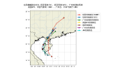
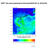
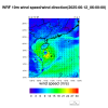
Our operational forecast system uses GFS (34 layers)(https://nomads.ncep.noaa.gov/pub/data/nccf/com/gfs/prod/gfs.20250612/00/atmos) and EC (14 layers) (https://data.ecmwf.int/forecasts/20250612/00z/ifs/0p25/oper/)parallel forecast systems to simulate Typhoon Butterfly. The initial time is 2025061200, and the simulation lasts for 3 days. I successfully ungribbed the soil temperature and humidity of ECMWF data using the modified rd_grib2.F code in WPS. However, the simulation results show that the intensity and path of the typhoon calculated by ECMWF are far from the actual ones. Please give me some suggestions on how to simulate the operational typhoon better, either from the perspective of namelist or TCbogus. I will use WRF's tc.exe to replace the original typhoon field of ECMWF to strengthen the typhoon.
eta_levels=1.0,0.99581471,0.98954858,0.98244697,0.97410409,0.96310165,0.95037795,0.93500000,0.92040000,0.90326080,
0.88261609,0.85926099,0.83240330,0.80400000,0.77020550,0.73612261,0.68989640,0.64133167,0.59070015,0.53836548,
0.48478833,0.43315023,0.38647380,0.34428224,0.30614468,0.27882868,0.25515020,0.23289543,0.21237592,0.19306879,
0.17524806,0.15891358,0.14390618,0.13025860,0.11729805,0.10501219,0.09339781,0.08221746,0.07150947,0.06148640,
0.05219412,0.04358802,0.03502770,0.02650660,0.01963142,0.01378411,0.00900000,0.00559472,0.00250000,0.0,