Hi, all
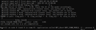
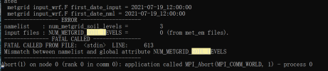
I got a strange problem when I run WRF 1km using ERA5. The detail is the rsl.error.0000 noticed the NUM_METGRID_SOIL_LEVELS = 0, mismatched with the namelist (Fig.1, and namelist attached). I changed it in namelist, but another error came across (Fig.2). It said there's no psfc, so I checked the met_em* and FILE* created in WPS4.0 (FILE_1km.log and met_em_1km.log attached), the Vtable is Vtable.ECMWF, there's no such variables. Also, I tried add sfcp_to_sfcp = .true. in namelist, but it didn't help neither.
However, I use the definitely same ERA5 data to run the same case in 3km and 8km (namelist are just varied the resolution and grids), there's no any problem, and I got the results successfully. So I'm sure the initialization data is quite alright. Also I checked the met_em* and FILE* in WPS, SOIL_LAYERS exist (FILE_8km.log and met_em_8km.log attached).
I really have no idea about this, can you give me some suggestions? Thank you for your help.