Hello everyone,
I’m running WRF v4.6.1 with the Urban Canopy Model (UCM) enabled, using the MODIFIED_IGBP_MODIS_NOAH land use classification and experiencing simulation crashes due to NaN temperature and a segmentation fault error.
Warning messages in `rsl.error.0000`:
```
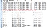
WARNING, FRC_URB2D = 0 BUT IVGTYP IS URBAN
WARNING, THE URBAN FRACTION WILL BE READ FROM URBPARM.TBL
USING DEFAULT URBAN MORPHOLOGY
```
Later during the simulation, it crashes with:
```
WARN5: NaN temperature; I,J,L,P= 196 35 1
forrtl: severe (174): SIGSEGV, segmentation fault occurred
```

My Questions:
1. Could the NaN temperature and segmentation fault be caused by `FRC_URB2D = 0` even though `IVGTYP = URBAN`?
I’m aware that this can lead to issues when urban physics is turned on. I’m using the default `URBPARM.TBL`.


2. Could this issue be related to incompatibility between my physics settings and the urban model (SLUCM)?
The model runs fine when I disable `sf_urban_physics`, but I need urban modeling for my study.
Any guidance on how to resolve this issue or what else to check would be greatly appreciated. Thank you in advance!
PS: Key `namelist.input` Settings as following:
&domains
time_step = 30,
time_step_fract_num = 0,
time_step_fract_den = 1,
max_dom = 3,
e_we = 307, 439, 79,
e_sn = 311, 451, 121,
e_vert = 45, 45, 45,
dzstretch_s = 1.2
eta_levels = 1.000, 0.955, 0.940, 0.925, 0.910, 0.900,
0.875, 0.850, 0.825, 0.800, 0.775, 0.750,
0.725, 0.700, 0.675, 0.650, 0.625, 0.600,
0.575, 0.550, 0.525, 0.500, 0.475, 0.450,
0.425, 0.400, 0.375, 0.350, 0.325, 0.300,
0.275, 0.250, 0.225, 0.200, 0.175, 0.150,
0.125, 0.100, 0.075, 0.050, 0.040, 0.030,
0.020, 0.010, 0.000
p_top_requested = 5000,
num_metgrid_levels = 38,
num_metgrid_soil_levels = 4,
dx = 9000, 3000, 1000,
dy = 9000, 3000, 1000,
grid_id = 1, 2, 3,
parent_id = 1, 1, 2,
i_parent_start = 1, 81, 201,
j_parent_start = 1, 81, 201,
parent_grid_ratio = 1, 3, 3,
parent_time_step_ratio = 1, 3, 3,
feedback = 1,
smooth_option = 1,
/
&physics
physics_suite = 'CONUS'
mp_physics = 5, 5, 5,
cu_physics = 1, 0, 0,
ra_lw_physics = 1, 1, 1,
ra_sw_physics = 1, 1, 1,
bl_pbl_physics = 7, 7, 7,
sf_sfclay_physics = 1, 1, 1,
sf_surface_physics = 2, 2, 2,
radt = 10, 10, 10,
bldt = 10, 10, 10,
cudt = 5, 0, 0,
icloud = 1,
num_land_cat = 61,
num_soil_layers = 4,
sf_urban_physics = 1, 1, 1,
! sf_urban_physics = 0, 0, 0,
sf_surface_mosaic = 1,
mosaic_cat = 3,
slucm_distributed_drag = .false.,
use_wudapt_lcz = 1,
distributed_ahe_opt = 2,
/
I’m running WRF v4.6.1 with the Urban Canopy Model (UCM) enabled, using the MODIFIED_IGBP_MODIS_NOAH land use classification and experiencing simulation crashes due to NaN temperature and a segmentation fault error.
Warning messages in `rsl.error.0000`:
```
WARNING, FRC_URB2D = 0 BUT IVGTYP IS URBAN
WARNING, THE URBAN FRACTION WILL BE READ FROM URBPARM.TBL
USING DEFAULT URBAN MORPHOLOGY
```
Later during the simulation, it crashes with:
```
WARN5: NaN temperature; I,J,L,P= 196 35 1
forrtl: severe (174): SIGSEGV, segmentation fault occurred
```

My Questions:
1. Could the NaN temperature and segmentation fault be caused by `FRC_URB2D = 0` even though `IVGTYP = URBAN`?
I’m aware that this can lead to issues when urban physics is turned on. I’m using the default `URBPARM.TBL`.


2. Could this issue be related to incompatibility between my physics settings and the urban model (SLUCM)?
The model runs fine when I disable `sf_urban_physics`, but I need urban modeling for my study.
Any guidance on how to resolve this issue or what else to check would be greatly appreciated. Thank you in advance!
PS: Key `namelist.input` Settings as following:
&domains
time_step = 30,
time_step_fract_num = 0,
time_step_fract_den = 1,
max_dom = 3,
e_we = 307, 439, 79,
e_sn = 311, 451, 121,
e_vert = 45, 45, 45,
dzstretch_s = 1.2
eta_levels = 1.000, 0.955, 0.940, 0.925, 0.910, 0.900,
0.875, 0.850, 0.825, 0.800, 0.775, 0.750,
0.725, 0.700, 0.675, 0.650, 0.625, 0.600,
0.575, 0.550, 0.525, 0.500, 0.475, 0.450,
0.425, 0.400, 0.375, 0.350, 0.325, 0.300,
0.275, 0.250, 0.225, 0.200, 0.175, 0.150,
0.125, 0.100, 0.075, 0.050, 0.040, 0.030,
0.020, 0.010, 0.000
p_top_requested = 5000,
num_metgrid_levels = 38,
num_metgrid_soil_levels = 4,
dx = 9000, 3000, 1000,
dy = 9000, 3000, 1000,
grid_id = 1, 2, 3,
parent_id = 1, 1, 2,
i_parent_start = 1, 81, 201,
j_parent_start = 1, 81, 201,
parent_grid_ratio = 1, 3, 3,
parent_time_step_ratio = 1, 3, 3,
feedback = 1,
smooth_option = 1,
/
&physics
physics_suite = 'CONUS'
mp_physics = 5, 5, 5,
cu_physics = 1, 0, 0,
ra_lw_physics = 1, 1, 1,
ra_sw_physics = 1, 1, 1,
bl_pbl_physics = 7, 7, 7,
sf_sfclay_physics = 1, 1, 1,
sf_surface_physics = 2, 2, 2,
radt = 10, 10, 10,
bldt = 10, 10, 10,
cudt = 5, 0, 0,
icloud = 1,
num_land_cat = 61,
num_soil_layers = 4,
sf_urban_physics = 1, 1, 1,
! sf_urban_physics = 0, 0, 0,
sf_surface_mosaic = 1,
mosaic_cat = 3,
slucm_distributed_drag = .false.,
use_wudapt_lcz = 1,
distributed_ahe_opt = 2,
/

