Scheduled Downtime
On Friday 21 April 2023 @ 5pm MT, this website will be down for maintenance and expected to return online the morning of 24 April 2023 at the latest

(RESOLVED) ERA5 data strange coastal boundary in simulations

This post was from a previous version of the WRF&MPAS-A Support Forum. New replies have been disabled and if you have follow up questions related to this post, then please start a new thread from the forum home page.

optism

Member
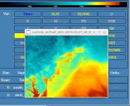
Hello, please see the attached image of 2m temperature for a WRF simulation. There's a strange jagged coastal boundary that doesn't look right. I'm using WPS/WRF 4.1.3 with 'default' geog_data_res. Any suggestions on what is going on?

Thanks!
 

Attachments

  • Screen Shot 2020-03-16 at 9.47.56 AM.png
    Screen Shot 2020-03-16 at 9.47.56 AM.png
    292.8 KB · Views: 1,254
This is a nesting case, I guess? Can you look at your wrfinput files and see whether the coastline is correctly described? Please also send me your namelist.wps and namelist.input to take a look.
 
Hi Ming, thanks for the reply and sorry for the delay. Crazy times.

I've attached both namelists. Thanks for looking into this strange coastal boundary issue!

Mike
 

Attachments

  • namelist.input
    6.3 KB · Views: 62
  • namelist.wps
    1.6 KB · Views: 81
Mike,
Based on your namelist.wps, I suppose you use ERA5 data as input to drive this case. Please let me know if I am wrong.
If you did use ERA5, I think that you didn't ungrib landsea data included in ERA5. Note that this is an important field that is used in interpolation of surface variables like SST, SOIL temperature and soil moisture etc.
If you have access to ERA5 data arrived in NCAR, the file below gives the landsea mask information for ERA5:
https://rda.ucar.edu/datasets/ds630.0/, where please find the datafile
e5.oper.invariant.128_172_lsm.regn320sc.2016010100_2016010100.grb
 
Great, thanks for the info. I download ERA5 data from the Copernicus API and did include the land-sea mask variable. So it should have been ungribbed with the rest of the surface variables.

I notice too that this issue doesn't occur for all simulations, the event on Oct 27 I posted below is just an instance. So I wonder if the land-sea mask variable was incorrect for that day?

Thanks again!
 
Top