Hi all I am trying to run the ARW on a regular lat-lon grid.
I need to do so in order to try to use fully an init data set with limited size:
My input is
LAT: 34.0 - 50.0
LON: 2.0 - 20.0
I am trying with the following set in namelist.wps
&geogrid
parent_id = 1,
parent_grid_ratio = 1,
i_parent_start = 1,
j_parent_start = 1,
e_we = 400,
e_sn = 440,
geog_data_res = 'modis_30s+30s',
dx = 0.040,
dy = 0.030,
map_proj = 'lat-lon',
ref_lat = 42.00,
ref_lon = 11.00,
truelat1 = 42.00,
truelat2 = 42.00,
stand_lon = -11.00,
pole_lat = 90.0,
pole_lon = 0.0,
ref_x = 200.0,
ref_y = 220.0,
/
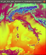
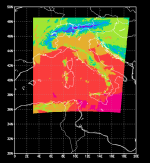
The netcdf output seems correct (see wrfout_netcdf.png) but when I pass trough unipost and copygb the result is a translated grid (unipost_copygb.png)
Do you have any idea where am I wrong?
Francesco
I need to do so in order to try to use fully an init data set with limited size:
My input is
LAT: 34.0 - 50.0
LON: 2.0 - 20.0
I am trying with the following set in namelist.wps
&geogrid
parent_id = 1,
parent_grid_ratio = 1,
i_parent_start = 1,
j_parent_start = 1,
e_we = 400,
e_sn = 440,
geog_data_res = 'modis_30s+30s',
dx = 0.040,
dy = 0.030,
map_proj = 'lat-lon',
ref_lat = 42.00,
ref_lon = 11.00,
truelat1 = 42.00,
truelat2 = 42.00,
stand_lon = -11.00,
pole_lat = 90.0,
pole_lon = 0.0,
ref_x = 200.0,
ref_y = 220.0,
/
The netcdf output seems correct (see wrfout_netcdf.png) but when I pass trough unipost and copygb the result is a translated grid (unipost_copygb.png)
Do you have any idea where am I wrong?
Francesco