Hello, I run the MPAS-A 7.3.
I get a strange output for the map of the geopotential height of the 850 hPa surface.
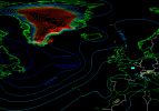
As seen in the capture screen, the height of the surface is higher on high terrain elevation, and as high as 3000 m over Greenland.

You can see also some unreasonable height over the alps or also over the Atlas mountain range. It is an output from the field "height_850hPa" that can be found inside the diag.* output files, and processed by convert_mpas.
I don't think that a pressure as high as 850 hPa can be measured at 3000 m ?
I attach some files connected to this simulation, so that you can see if there is something wrong.
The map of the geopotential at 500 hPa does not have this behaviour.
Thank you if you could give your feeling/understanding on that.
I get a strange output for the map of the geopotential height of the 850 hPa surface.
As seen in the capture screen, the height of the surface is higher on high terrain elevation, and as high as 3000 m over Greenland.

You can see also some unreasonable height over the alps or also over the Atlas mountain range. It is an output from the field "height_850hPa" that can be found inside the diag.* output files, and processed by convert_mpas.
I don't think that a pressure as high as 850 hPa can be measured at 3000 m ?
I attach some files connected to this simulation, so that you can see if there is something wrong.
The map of the geopotential at 500 hPa does not have this behaviour.
Thank you if you could give your feeling/understanding on that.
Attachments
Last edited:
