Yonghang Xie
New member
Dear Sir or Miss
It is good to make a question here to do a better study for WRF.
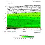
While doing the post-process for a cross-section from the wrf_output, I used the wrf_CrossSection4.ncl. But, this script can not get the data over 0m to 200m near the surface layer. Maybe you all know that the surface layer analyzation is very important to the local environment and climate.
Therefore, does someone know there is an NCL script that can figure out this problem or make an explanation for us?
The attaching file is the result got by the wrf_CrossSection4.ncl.
That is all. Best wishes.
Yonghang Xie
e-mail: tohokuxyh@gmail.com
It is good to make a question here to do a better study for WRF.
While doing the post-process for a cross-section from the wrf_output, I used the wrf_CrossSection4.ncl. But, this script can not get the data over 0m to 200m near the surface layer. Maybe you all know that the surface layer analyzation is very important to the local environment and climate.
Therefore, does someone know there is an NCL script that can figure out this problem or make an explanation for us?
The attaching file is the result got by the wrf_CrossSection4.ncl.
That is all. Best wishes.
Yonghang Xie
e-mail: tohokuxyh@gmail.com