518er2005
Member
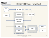
I am trying to do a limited area simulation (LAS) using 10 km. As we all know we need static data for running any simulation in MPAS-A, so in the case of LAS as shown in the tutorial, the static data created before for 240 km global simulation was used to create the static data for the LAS by using the create region tool. So my query is whether it is correct to use the create region tool at the beginning itself by using it with the gridded mesh to create a limited region mesh of 10 km then create the static data of that limited mesh and proceed further for the simulation?

