Hello,
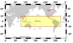
I am planning on running a series of simulations for the Tropical Pacific. Unfortunately, the current meshes do not provide the necessary spatial coverage. Is there any way I could have access to make my own custom mesh? For example, I want to cover (-30S to 30N), (90E to 330E) at a 15-60km resolution (see attached image).
Also, technically I can survive with an eastern boundary closer to 310E (vs. 330E). Are you able to estimate the difference in running the additional 20˚ longitude?
Thanks as always,
Zach