Scheduled Downtime
On Friday 21 April 2023 @ 5pm MT, this website will be down for maintenance and expected to return online the morning of 24 April 2023 at the latest

'Error in interpolation of st_fg to MPAS grid' with variable-resolution mesh simulation

This post was from a previous version of the WRF&MPAS-A Support Forum. New replies have been disabled and if you have follow up questions related to this post, then please start a new thread from the forum home page.

wuzhongyuan

New member
Good morning,
I want to run MPAS for regional simulation with variable-resolution mesh. So I use grid_rotate to generate a japan.grid.nc file with x20.835586.grid.nc file as input for a 60-3km variable-resolution mesh. I use this file to product IC/BC。But there is an error with st_fg when I running init_atmosphere_model. It seems that the interpolation is not in accord with MPAS grid. And the value of the num_st field is 80. So what's the reason for this problem. and How to solve it?
I would appreciate any advice as to how I may resolve this. Thanks!
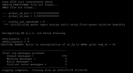
error_20200724075457.png
 
The error message
Code:
Error in interpolation of st_fg to MPAS grid: num_st = XX
generally indicates that there are grid cells that have a soil temperature value less than or equal to zero.

What soil temperature dataset are you using? Or, more generally, what dataset are you trying to use for initial conditions?
 
Thanks for your reply.
The Error happened maybe about the simulated region. And there are indeed most of grid cells soil temperature less than zero. I am using the NCEP GFS dataset for initial conditions. And the dataset has soil temperature dataset among the rest.
I thank that the NCEP GFS soil temperature dataset does not right for the simulated region. And what is the soil temperature dataset can be using for the simulated region.
 
Thanks for your reply.

The problem has been solved by changed the ERROR type with WARNING type. And I have changed the code.

And it works.
 
Thanks very much for following up. In general, the soil temperature and soil moisture fields from NCEP's GFS should work fine.

Simply changing an ERROR into a WARNING may not always be a good idea -- the ERROR messages in the init_atmosphere_model program are designed to prevent the model from running with incorrect data. If the zero or negative soil temperatures are all over water, then in this case you may not have problems; but, if there are any zero or negative soil temperatures over land, you won't be able to correctly run the model (except, e.g., if you were to disable various physics schemes, including the land-surface scheme).

So, I think it would be a good idea to proceed with caution and to carefully check your initial conditions. As another easy test, it may be worth trying to create initial conditions from the same GFS dataset on a coarse, quasi-uniform mesh like the 120-km mesh. Doing so should require very little computation in comparison to the x20.835586 mesh, and it would help to determine whether there might be an underlying problem with the GFS data you've processed or with the 60-3 km "static" file.
 
Thanks for your replay.
I thank that the soil temperature and soil moisture fields from NCEP's GFS should work fine. if I used it for the simulated 120-km mesh. And there is no error happened with the mesh. It means that the NCEP's GFS soil temperature and soil moisture fields is not bad. It has been happened with an error when I used it for the x20.835586 mesh. So it means that it is interpolated the meteorological data wrong. And the MPAS can not used for the x20.835586 mesh.
And it works latter.
 
Top