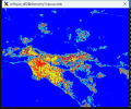
Hi, when I use the NLCD land-use dataset to simulate WRF-SLUCM in Los Angeles, the urban fraction (FRC_URB2D) field looks correct in wrfinput_d02 (continuous high values over the LA basin), as shown below:

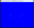
but in wrfout_d02 it becomes almost all zeros with only scattered pixels, almost looks the same to UTYPE_URB2D, as shown below:

I also attached the namelist.wps and namelist.input for your reference.
I’m enabling SLUCM (sf_urban_physics = 1).
I would appreciate guidance on what I’m doing wrong, or whether I’m missing a required switch for NLCD.
More information are:

but in wrfout_d02 it becomes almost all zeros with only scattered pixels, almost looks the same to UTYPE_URB2D, as shown below:

I also attached the namelist.wps and namelist.input for your reference.
I’m enabling SLUCM (sf_urban_physics = 1).
I would appreciate guidance on what I’m doing wrong, or whether I’m missing a required switch for NLCD.
More information are:
- WRF: v4.6.1
- WPS: v4.6.1
- Geog data: NLCD2011 (nlcd2011_9s) + defaults (path to WPS_GEOG)
- Domains: d01 ~4 km, d02 ~1 km over Southern California
