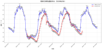
I'm currently using the WRF - BEP - BEM model to simulate heatwave events in my study area. However, I've encountered a puzzling issue regarding 10m wind speed. The simulated wind speeds exhibit extremely violent fluctuations, whereas the observational data from meteorological stations are relatively smooth.
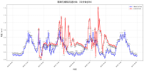
I've attached a graph for your reference, which clearly shows the stark contrast between the two. The red line representing the simulated wind speed has large and frequent spikes, while the blue line of the observational data varies in a much more stable manner.
Has anyone else faced a similar issue when using the WRF - BEP - BEM model for heatwave simulations? Any suggestions on diagnosing and solving these problems, especially improving the model's performance regarding the wind speed fluctuations and the low 2m air temperature, would be greatly appreciated. Thank you!