Hello.
I would like to use this dataset https://catalogue.ceh.ac.uk/documents/36df244e-11c8-44bc-aa9b-79427123c42c for urban parameter. I have downloaded the data and I used https://github.com/openwfm/convert_geotiff to convert it from geotiff to binary files.
How do I determine whether the binary files are okay or not? I have attached the converted binary files in a zip file. It should be 1.1 GB uncompressed. The data only provide .geotiff, and no .tfw file. In the index file (I have attached it as index.txt), I determined that kown_lat and known_lon is correct and is the northwest corner location. How do I determine the other parameters? Such as dx and dy, which I assume 25 (meters)? tile_x and tile_y would be 100, judging from the naming of the binaries file, for example, "00001-00100.12901-13000".
Referring to https://www2.mmm.ucar.edu/wrf/users/docs/user_guide_v4/v4.2/users_guide_chap3.html#_Creating_an_Urban, I'm using https://www2.mmm.ucar.edu/people/duda/uf/uf.c to extract just the urban parameter. As I understand, the new created file should be renamed as the same the input file, is this correct? I should use loop to go through each file right?
Inside the uf.c file, the hard-coded value of 22,23, and 24 should be changed to match the data I'm using right? Which is given below (from the documentation of the data). There are 5 values that should be relevant (3, 4, 5, 6, 7 and 9). Looking at the source code of uf.c, I believe I can increase the processing of just three variables to five if I need it to be.

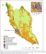
Figure 7: Land use map of Peninsular Malaysia, with a zoom into Kuala Lumpur (where no detailed state polygon data was available, infilled using CCI Land Cover)
Regarding the usage of this program, I have questions about the percentage assignment. I believe category 3,4 and '5 and 6' can be matched to category 22,23,and 24 in NLCD. What should I do 9 (Urban) and 7 (Roads)? For 9 (Urban), it seems to be a large area of unprocessed data. From personal experience and knowledge, it should be a mixture of 4, 5 and 6 like its surrounding. Would it be acceptable to use the following values?
I would like to use this dataset https://catalogue.ceh.ac.uk/documents/36df244e-11c8-44bc-aa9b-79427123c42c for urban parameter. I have downloaded the data and I used https://github.com/openwfm/convert_geotiff to convert it from geotiff to binary files.
How do I determine whether the binary files are okay or not? I have attached the converted binary files in a zip file. It should be 1.1 GB uncompressed. The data only provide .geotiff, and no .tfw file. In the index file (I have attached it as index.txt), I determined that kown_lat and known_lon is correct and is the northwest corner location. How do I determine the other parameters? Such as dx and dy, which I assume 25 (meters)? tile_x and tile_y would be 100, judging from the naming of the binaries file, for example, "00001-00100.12901-13000".
Referring to https://www2.mmm.ucar.edu/wrf/users/docs/user_guide_v4/v4.2/users_guide_chap3.html#_Creating_an_Urban, I'm using https://www2.mmm.ucar.edu/people/duda/uf/uf.c to extract just the urban parameter. As I understand, the new created file should be renamed as the same the input file, is this correct? I should use loop to go through each file right?
Inside the uf.c file, the hard-coded value of 22,23, and 24 should be changed to match the data I'm using right? Which is given below (from the documentation of the data). There are 5 values that should be relevant (3, 4, 5, 6, 7 and 9). Looking at the source code of uf.c, I believe I can increase the processing of just three variables to five if I need it to be.
Code:
1	Agriculture (non-paddy)
2	Agriculture (paddy)
3	Rural Residential
4	Urban Residential
5	Commercial and Institutional
6	Industrial and Infrastructure
7	Roads
8	Others (forest, lakes/reservoirs, bare land, beach)
9	Urban
Figure 7: Land use map of Peninsular Malaysia, with a zoom into Kuala Lumpur (where no detailed state polygon data was available, infilled using CCI Land Cover)
Regarding the usage of this program, I have questions about the percentage assignment. I believe category 3,4 and '5 and 6' can be matched to category 22,23,and 24 in NLCD. What should I do 9 (Urban) and 7 (Roads)? For 9 (Urban), it seems to be a large area of unprocessed data. From personal experience and knowledge, it should be a mixture of 4, 5 and 6 like its surrounding. Would it be acceptable to use the following values?
Code:
Data		NLDC		Percentage
Category	category
3		22		50
4		23		90
5		24		95
6		24		95
7				95?
9		23,24		85?