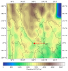
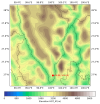
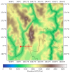
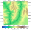
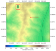
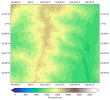
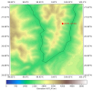
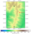
Hi everyone,I’m running into an issue with the geo_em.d04.nc file produced by WPS. I updated the terrain (HGT) using ASTER 30 m GeoTIFFs that I converted, and geogrid.exe reported that the HGT was read successfully.
However, in my five-nest WRF-LES setup with resolutions 9 km → 3 km → 1 km → 0.333 km → 0.111 km, the generated geo_em.d04 and geo_em.d05 files show terrain values that don’t match the actual HGT (see the attached figure).
These HGT anomalies are causing excessively large CFL values during the subsequent WRF-LES runs and are affecting model stability.If anyone could offer suggestions or guidance on what might be causing this and how to resolve it, I would be very grateful. Thank you very much for your time and help!

