Scheduled Downtime
On Friday 21 April 2023 @ 5pm MT, this website will be down for maintenance and expected to return online the morning of 24 April 2023 at the latest

How to create the 2 nested mesh with the different resolution

This post was from a previous version of the WRF&MPAS-A Support Forum. New replies have been disabled and if you have follow up questions related to this post, then please start a new thread from the forum home page.

Hi everyone,
I'm a new user of MPAS model. After I read many tutorials of this model, I realized that the available mesh on the website just be a single mesh. So I have a question is how to create the 2 nested mesh with different resolution?
Any suggestions will be appreciated!
Thanks in advance.
 
Hi ntmanhvn181, sorry for the slow response on this. There is not really a supported way to do nested meshes as one would do in the WRF model. The variable resolution meshes are the MPAS way of 'nesting' different resolutions for a single simulation.
 
Hi mcurry,
Thank you for your reply!
I have a question related to the variable resolution meshes. For example, with the case of 60-km–3-km mesh, if I want to plot the result of 3km output (RAINC, RAINNC or many others variables), how will I do to plot the exact resolution that I want?
Thank you in advance.
 
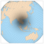
Just to make sure I understand the question, are you asking how you can plot just the geographical region that is covered by the (approximately) 3-km part of the mesh? Unlike as in nested-grid models, there is a single, continuous grid with smoothly varying grid spacing in MPAS; for example:
60-3_mesh.png
So, in plotting the model output, you will necessarily be using the 3-km resolution output in the geographic region covered by the refined part of the 60-3 km mesh.
 
Top