I writing to find out how to post process precipitation from the MPAS model as well as the suggested best practices for configuring the MPAS model to simulate rainfall correctly.
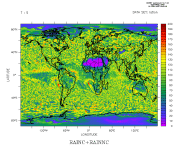
I have ran a 30 year variable resolution simulation with MPAS and I am about to analyse precipitation. When I plot a single day of rainfall over my area of interest it looks patchy (see rain.gif) and not as smooth as WRF and observation data. Therefore, I am wondering if I configured the model correctly or not.
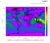
Particularly, I enabled the option config_bucket_update = '01:00:00' in the model physics, I noticed that the accumulated precipitation does not build up continuously (that is cumulative sum from first day of simulation to last day of simulation). Therefore, it is not clear to me if I need to de-accumulate the rainfall or not. This is because the rainfall time series does not look like an accumulation from the first hour of simulation to the last hour.
I configured the model to write diag files at 6 hourly interval as below:
//////////////////////////////////
diag.1987-01-01_00.00.00.nc
diag.1987-01-01_06.00.00.nc
diag.1987-01-01_12.00.00.nc
diag.1987-01-01_18.00.00.nc
///////////////////////////////////
I post-process the rainfall from the diag file using convert_mpas tool to get a single file (latlon.nc) by running the following command:
/////////////////////////////////
convert_mpas mpas_init.nc diag*.nc
/////////////////////////////////
I want to calculate daily rainfall (mm/day) from the 6 hourly output and it is not clear to me if I need to take the average of the 6 hourly output using a tool like cdo after combining the 6 hourly output into a single file. That is, is it OK to do something like below?
//////////////////////////////////
cdo daymean latlon.nc mydailyfile.nc
//////////////////////////////////
Briefly:
1- Do I need to de-accumulate MPAS rainc and rainnc fields if I set the option config_bucket_update = '01:00:00' in my namelist (attached)?
2- Is there any example or documentation you can refer me to as I have been unable to get this information from the user's guide and presentations?
3- How can I process rainfall from MPAS simulation so that it is comparable with observations and WRF simulations?
4- How can one configure the MPAS model to simulate rainfall well over complex terrain? Do you have any comments about my attached namelist?
5- I see from ncdump of one of the diag*.nc files that the unit of rainc is "mm", is this mm per day ? (see diag_file_meta.txt)
Thanks while looking forward to hearing from you.


