Hello all,
I'm making a WRF run forced wit ERA5 reanalysis, and I noted that ERA5 SST fields look weird...
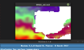
First, the mask values over land is 0ºC, which when WPS will interpolate the fields in metgrid will give irrealistic surface temperature fields over coastal areas. obviously, this will in turn produce WRF outputs with faulty temperature fields (and surface winds, and other vars tied to the surface temperature fields), as it can be seen below.

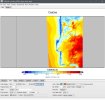
Second, the coastline in ERA5 SST field seems too coarse, considering that ERA5 has ~ 25-30 km of horizontal resolution (image below). This does not happen for other variables such has skintemp or surface temperature, and so on.

So, I have 2 questions:
First, has anyone else noted these ERA5 SST issues? Is ECMWF aware of these issues?
Second, what is the fix to run WRF with ERA5? i was thinking of replacing the SSTs with SKINTEMP in the WPS Vtable for ERA5, they appear to have the same values over the ocean.
Appreciate any feedback on this
I'm making a WRF run forced wit ERA5 reanalysis, and I noted that ERA5 SST fields look weird...
First, the mask values over land is 0ºC, which when WPS will interpolate the fields in metgrid will give irrealistic surface temperature fields over coastal areas. obviously, this will in turn produce WRF outputs with faulty temperature fields (and surface winds, and other vars tied to the surface temperature fields), as it can be seen below.

Second, the coastline in ERA5 SST field seems too coarse, considering that ERA5 has ~ 25-30 km of horizontal resolution (image below). This does not happen for other variables such has skintemp or surface temperature, and so on.

So, I have 2 questions:
First, has anyone else noted these ERA5 SST issues? Is ECMWF aware of these issues?
Second, what is the fix to run WRF with ERA5? i was thinking of replacing the SSTs with SKINTEMP in the WPS Vtable for ERA5, they appear to have the same values over the ocean.
Appreciate any feedback on this
Last edited:
