Hello.
I am using WRF model to run a real case in Dhaka, Bangladesh region to analyze the urban breeze. I am using a 4 nested domain, and i want the modify my geo_em.d04 data.
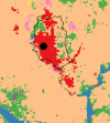
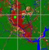
The issue is the landuse. I used two landuse types in the wrf default landuse: modis_landuse_20class_30s and modis_landuse_20class_15s. The first one overestimates the urban area in Dhaka and the second one underestimates it, especially in the south of Dhaka. I want to use modis_landuse_20class_15s but modify the urban landuse based on the landuse map I created using Landsat 8 OLI data (supervised classification).
I am attaching the maps. The urban area is indicated in red. I have the urban grids in my classified image. My aim is to convert the same grids in the LU_INDEX variable in the geo_em.d04 file to urban (=13). Since urban area is my primary concern and the urban breeze depends highly on the landuse, I must make such modification to get proper wrf_output.
The classified image is .tiff format and prepared using QGIS. How can I modify the geo_em.d04 file and use it to run the WRF model successfully?
Thank you.


