yanhongyi
Member
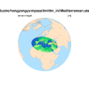
I've successfully get a regional Mediterranean.static.nc file after running limited-area mpas tool (GitHub - MPAS-Dev/MPAS-Limited-Area: Python tool to create a regional subset of a global MPAS Mesh).
The original x5.xxxxx.static.nc (15km-3km) has no problem because it can be processed successfully to generate x5.xxxxx.init.nc file and finally I can run the global simulation successfully. I've also checked the x5.xxxxx.static.nc file, it's OK and can be plotted by ncl script.
However, when I used the Mediterranean.static.nc file obtained by limited-area mpas tool (this Mediterranean.static.nc is successfully outputed by limited-area mpas tool without any error) to generate the .init.nc file, MPAS-A stops without .err files. The .out files seem to be OK but it did stop. When I check the slurm file (which contains some information reported by the supercomputer), I found it:
"forrtl: severe (408): fort: (7): Attempt to use pointer LATCELL when it is not associated with a target"
I've no idea...Can anybody help me with this problem?
Attached are my setting and some other files