Hi all,
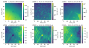
I'm currently running a nested (25km > 5km > 1km) configuration centred over Lubbock, Texas, yet I'm finding some intriguing artefacts in my output fields.
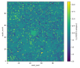
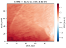
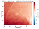
The plots attached show a handful of variables of interest where some clear features are present:
1. The town of Lubbock itself (centre of the domain).
2. Odd speckle effects which create an almost static like appearance.
Can anyone explain what's going on here? It seems unrealistic to have a town so aggressively noticeable in all time steps, and the speckled field (particularly the OLR/U10/V10) seems very unrealistic.
Attached is the namelist.input for the described run.
Thanks for the help!
Ty
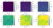
I'm currently running a nested (25km > 5km > 1km) configuration centred over Lubbock, Texas, yet I'm finding some intriguing artefacts in my output fields.
The plots attached show a handful of variables of interest where some clear features are present:
1. The town of Lubbock itself (centre of the domain).
2. Odd speckle effects which create an almost static like appearance.
Can anyone explain what's going on here? It seems unrealistic to have a town so aggressively noticeable in all time steps, and the speckled field (particularly the OLR/U10/V10) seems very unrealistic.
Attached is the namelist.input for the described run.
Thanks for the help!
Ty