Hello,
I'm using NCL to create a netCDF file with height data at pressure levels as opposed to eta levels. This has involved the use of the wrf_user_intrp3d() function to interpolate height fields at 19 different pressure levels. The code I've used can be found here: https://github.com/rclare2/ncl-Scripts/blob/master/PressureLevelHeights_netCDF.ncl
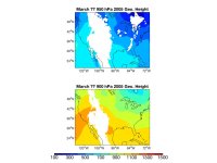
The attachment shows my colleague's efforts to plot the data which show expected missing values at lower levels where terrain is in the way. We're particularly interested, however, in the 950 mb level where large areas of missing values appear over eastern Ontario. On this day (March 6, 2005), there is an ordinary low pressure system in that region but we were surprised to find the missing values at 950 mb in an area with such low topography.
Is this a problem stemming from vertical interpolation too close to the lower boundary or something else entirely? Can it be fixed? Is there another, more reliable way to convert WRF data to pressure levels?
Thank you,
Ryan Clare
University of Wisconsin-Madison

