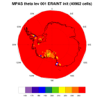
Hi:
I have a problem with running MPAS with ERA interim model level files. I followed the procedure in
http://metclim.ucd.ie/2018/03/wrfv3-9-1-with-era-interim-data-on-orr2/
to get the WPS intermediate file for pressure, RH, and GHT in addition to using ungrib.exe to get the intermediate
files for the 2D surface fields and 3D fields for u, v, T, SPFH. I "cat" all three files into one and then executed
./init_atmosphere_model
I am running for a case initialized on 2018-07-30_00 and with the "40962" grid. For some of the ice points in the polar region, I am getting very low theta at the 1st model level in x1.40962.init.nc. e.g., a value of 138.313 K at 72.553818 S 165.703690 E. I did not see very cold temperature at the 1st model level in the original ERA interim file. The 2m temperature and soil temperature in MPAS did not have temperatures that were that cold.
I used the same file to run WRF over Antarctica at the problematic point, the initial theta was around 220-230 K.
I am attaching my namelist and the theta at 1st level from x1.40962.init.nc.
I am using MODIS landtype (USGS had the similar problem).
Thanks in advance for any help you can offer!

