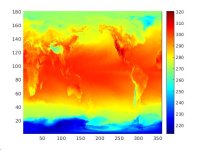
In the first plot you've attached, it looks like the SST field is reasonable over water points and only "distorted" over land points (where the SST isn't used). If the input SST field to the init_atmosphere_model program is masked out over land and contains only valid values over water, if I recall correctly, the init_atmosphere_model program will extrapolate to land points from the nearest water points, giving rise to patterns like the one you've shown.
If you ignore the land points, and if the SST field over water is as you expect, then I think your simulations may be fine. As a test, you could modify the SST field in your surface update file so that the SST field is, say, 0 K over land; re-running a test simulation should show no change in results, confirming that the SST field over land points is in fact ignored by the model.