Hi WRF team. I am currently experiencing error when I try to change land use data in geogrid tbl. I downloaded a 2018 modis land use data which i plan to use as my base land use, hence I assigned it in land use priority 1
MODIS land use has two maps which I mosaic. After transforming it into binary file, and setting my path to it in the geogrid,tbl, I ran wrf with the namelist.wps details below,
Geogrid then will show errors like this
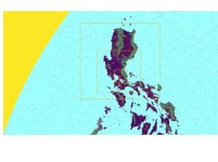
Looking at the domain was located inside updated land use map, so I was wondering what seems to be the problem. I am attaching all relevant files. Thanks for the help.
Code:
name=LANDUSEF
        priority=1
	dominant = LU_INDEX
        dest_type=categorical
        z_dim_name=land_cat
        landmask_water =    nlcd2006_9s:17         # Calculate a landmask from this field
        landmask_water =   nlcd2006_30s:17         # Calculate a landmask from this field
        landmask_water =    nlcd2011_9s:17         # Calculate a landmask from this field
        landmask_water =       nlcd2006:17         # Calculate a landmask from this field
        landmask_water =       ssib_10m:16         # Calculate a landmask from this field
        landmask_water  =       ssib_5m:16         # Calculate a landmask from this field
        landmask_water =      modis_15s:17         # Calculate a landmask from this field
        landmask_water =      modis_30s:17         # Calculate a landmask from this field
        landmask_water = modis_30s_lake:17,21      # Calculate a landmask from this field
        landmask_water =       usgs_30s:16         # Calculate a landmask from this field
        landmask_water =     usgs_lakes:16,28      # Calculate a landmask from this field
        landmask_water =    modis_lakes:17,21      # Calculate a landmask from this field
        landmask_water =        usgs_2m:16         # Calculate a landmask from this field
        landmask_water =        usgs_5m:16         # Calculate a landmask from this field
        landmask_water =       usgs_10m:16         # Calculate a landmask from this field
        landmask_water =        default:17,21      # Calculate a landmask from this field
        interp_option =    nlcd2006_9s:average_gcell(0.0)
        interp_option =   nlcd2006_30s:average_gcell(0.0)
        interp_option =    nlcd2011_9s:average_gcell(0.0)
        interp_option =       nlcd2006:nearest_neighbor
        interp_option =       ssib_10m:four_pt
        interp_option =        ssib_5m:four_pt
        interp_option =      modis_15s:nearest_neighbor
        interp_option =      modis_30s:nearest_neighbor
        interp_option = modis_30s_lake:nearest_neighbor
        interp_option =       usgs_30s:nearest_neighbor
        interp_option =     usgs_lakes:nearest_neighbor
        interp_option =    modis_lakes:nearest_neighbor
        interp_option =        usgs_2m:four_pt
        interp_option =        usgs_5m:four_pt
        interp_option =       usgs_10m:four_pt
        interp_option =        default:nearest_neighbor
        rel_path =    nlcd2006_9s:nlcd2006_ll_9s/
        rel_path =   nlcd2006_30s:nlcd2006_ll_30s/
        rel_path =    nlcd2011_9s:nlcd2011_ll_9s/
        rel_path =       nlcd2006:nlcd2006_ll_30s/
        rel_path =       ssib_10m:ssib_landuse_10m/
        rel_path =        ssib_5m:ssib_landuse_5m/
        rel_path =      modis_15s:modis_landuse_20class_15s/
        rel_path =      modis_30s:modis_landuse_20class_30s/
        rel_path = modis_30s_lake:modis_landuse_20class_30s_with_lakes/
        rel_path =       usgs_30s:landuse_30s/
        rel_path =     usgs_lakes:landuse_30s_with_lakes/
        rel_path =    modis_lakes:modis_landuse_21class_30s/
        rel_path =        usgs_2m:landuse_2m/
        rel_path =        usgs_5m:landuse_5m/
        rel_path =       usgs_10m:landuse_10m/
        rel_path =       default:[b]metro_manila[/b]/
MODIS land use has two maps which I mosaic. After transforming it into binary file, and setting my path to it in the geogrid,tbl, I ran wrf with the namelist.wps details below,
Code:
&share
 wrf_core = 'ARW',
 max_dom = 3,
 start_date = '2018-04-21_00:00:00', '2018-04-21_00:00:00', '2018-04-21_00:00:00',
 end_date   = '2018-04-30_00:00:00', '2018-04-30_00:00:00', '2018-30-21_00:00:00',
 interval_seconds = 21600,
 io_form_geogrid = 2,
 debug_level = 0,
/

&geogrid
 parent_id         = 1,1,2,
 parent_grid_ratio = 1,5,5,
 i_parent_start    = 1,38,42,
 j_parent_start    = 1,27,44,
 e_we          = 100,111,151,
 e_sn          = 105,121,221,
 geog_data_res = '30s','30s',metro_manila+30s',
 dx = 7500,
 dy = 7500,
 map_proj =  'mercator',
 ref_lat   = 15.474,
 ref_lon   = 121.125,
 truelat1  = 15.474,
 truelat2  = 0,
 stand_lon = 121.125,
 geog_data_path = '/home/gil/WRF/WPS_GEOG',
 opt_geogrid_tbl_path = '/home/gil/WRF/WPS4.0/geogrid/',
 ref_x = 50.0,
 ref_y = 52.5,
/

&ungrib
 out_format = 'WPS',
 prefix = 'FILE',
/

&metgrid
 fg_name = 'FILE',
 io_form_metgrid = 2,
 opt_output_from_metgrid_path = '/home/gil/WRF/Test/SLUCM/',
 opt_metgrid_tbl_path = '/home/gil/WRF/Test/SLUCM/',
/

&mod_levs
 press_pa = 201300 , 200100 , 100000 ,
             95000 ,  90000 ,
             85000 ,  80000 ,
             75000 ,  70000 ,
             65000 ,  60000 ,
             55000 ,  50000 ,
             45000 ,  40000 ,
             35000 ,  30000 ,
             25000 ,  20000 ,
             15000 ,  10000 ,
              5000 ,   1000
 /
Geogrid then will show errors like this
Code:
WARNING: In source tile /home/gil/WRF/WPS_GEOG/metro_manila/00001-03199.00001-01200, point (748, 214) has an invalid category of 17
WARNING: In source tile /home/gil/WRF/WPS_GEOG/metro_manila/00001-03199.00001-01200, point (749, 213) has an invalid category of 17
WARNING: In source tile /home/gil/WRF/WPS_GEOG/metro_manila/00001-03199.00001-01200, point (749, 214) has an invalid category of 17
WARNING: In source tile /home/gil/WRF/WPS_GEOG/metro_manila/00001-03199.00001-01200, point (750, 213) has an invalid category of 17
WARNING: In source tile /home/gil/WRF/WPS_GEOG/metro_manila/00001-03199.00001-01200, point (750, 214) has an invalid category of 17
WARNING: In source tile /home/gil/WRF/WPS_GEOG/metro_manila/00001-03199.00001-01200, point (739, 215) has an invalid category of 17
WARNING: In source tile /home/gil/WRF/WPS_GEOG/metro_manila/00001-03199.00001-01200, point (740, 215) has an invalid category of 17
WARNING: In source tile /home/gil/WRF/WPS_GEOG/metro_manila/00001-03199.00001-01200, point (741, 215) has an invalid category of 17
Looking at the domain was located inside updated land use map, so I was wondering what seems to be the problem. I am attaching all relevant files. Thanks for the help.