Dear WRF support team,
I am using WRF version 4.1.3. over several mountain regions with domains of 25 km, 5 km, 1 km, 200 m, 40 m. I downloaded 1) SRTM1 data (~30 m) via the USGS EarthExplorer, and 2) ASTGTM (~30 m) via EarthDataSearch from Nasa, merged all tif files to one big tif file for each SRTM1 and ASTGTM, and then followed steps 4-8 from this post: https://forum.mmm.ucar.edu/phpBB3/viewtopic.php?t=9628
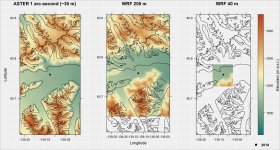
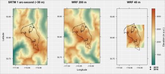
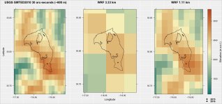
When running geogrid and plotting the output together with shapefiles of the region, I see large shifts for both 1) SRTM1 and 2) ASTGTM. I have attached the plots, where you can see that the shape aligns well when plotted on the original SRTM1/ASTGTM tif file, but not for WRF geo_em output. However, I did a test with the default USGS GMTED2010 30 arc-sec data from WPS (for 30 km, 10 km, 3.33 km, 1.11 km domains), and there is NO shift here.
My input SRTM1/ASTGTM tif files have the coordinate reference system (crs): "+proj=longlat +datum=WGS84 +no_defs".
My WRF-model uses Lambert conformal conic (LCC) projection.
I have read this paper (https://www.researchgate.net/publication/258805934_Overlapping_Interests_The_Impact_of_Geographic_Coordinate_Assumptions_on_Limited-Area_Atmospheric_Model_Simulations), where a huge shift could be seen because the data was transformed from WGS84 to the sphere BEFORE they were ingested and remapped to the WRF domains by geogrid.exe - but this does not seem to be the case for me, if I understand correctly, because I am using WGS84 for my input data.
Can you please help me? Thanks a lot!
My index file for SRTM1 data () looks as follows:
======================================================
projection = regular_ll
known_x = 1
known_y = 21601
known_lat = 55.000137
known_lon = -123.000275
dx = 5.524358e-04
dy = 2.762179e-04
type = continuous
signed = yes
units = "meters MSL"
description = "Topography height"
wordsize = 4
tile_x = 2291
tile_y = 2291
tile_z = 1
tile_bdr = 3
missing_value = 32768
scale_factor = 1.000000
row_order = bottom_top
endian = little
==================================
I have also tried to actually implement different coordinate reference system (crs) transformations to the original SRTM1 file (with "+proj=longlat +datum=WGS84 +no_defs") BEFORE using convert_geotiff:
1) I transformed it to regular lat long, because I had the suspicion that convert_geotiff assumes that --> didn't help, I can still see the shift
2) I transformed it to LCC, but was unsuccessful so far (HGT_M shows 0 in the geo_em files)
I am using WRF version 4.1.3. over several mountain regions with domains of 25 km, 5 km, 1 km, 200 m, 40 m. I downloaded 1) SRTM1 data (~30 m) via the USGS EarthExplorer, and 2) ASTGTM (~30 m) via EarthDataSearch from Nasa, merged all tif files to one big tif file for each SRTM1 and ASTGTM, and then followed steps 4-8 from this post: https://forum.mmm.ucar.edu/phpBB3/viewtopic.php?t=9628
When running geogrid and plotting the output together with shapefiles of the region, I see large shifts for both 1) SRTM1 and 2) ASTGTM. I have attached the plots, where you can see that the shape aligns well when plotted on the original SRTM1/ASTGTM tif file, but not for WRF geo_em output. However, I did a test with the default USGS GMTED2010 30 arc-sec data from WPS (for 30 km, 10 km, 3.33 km, 1.11 km domains), and there is NO shift here.
My input SRTM1/ASTGTM tif files have the coordinate reference system (crs): "+proj=longlat +datum=WGS84 +no_defs".
My WRF-model uses Lambert conformal conic (LCC) projection.
I have read this paper (https://www.researchgate.net/publication/258805934_Overlapping_Interests_The_Impact_of_Geographic_Coordinate_Assumptions_on_Limited-Area_Atmospheric_Model_Simulations), where a huge shift could be seen because the data was transformed from WGS84 to the sphere BEFORE they were ingested and remapped to the WRF domains by geogrid.exe - but this does not seem to be the case for me, if I understand correctly, because I am using WGS84 for my input data.
Can you please help me? Thanks a lot!
My index file for SRTM1 data () looks as follows:
======================================================
projection = regular_ll
known_x = 1
known_y = 21601
known_lat = 55.000137
known_lon = -123.000275
dx = 5.524358e-04
dy = 2.762179e-04
type = continuous
signed = yes
units = "meters MSL"
description = "Topography height"
wordsize = 4
tile_x = 2291
tile_y = 2291
tile_z = 1
tile_bdr = 3
missing_value = 32768
scale_factor = 1.000000
row_order = bottom_top
endian = little
==================================
I have also tried to actually implement different coordinate reference system (crs) transformations to the original SRTM1 file (with "+proj=longlat +datum=WGS84 +no_defs") BEFORE using convert_geotiff:
1) I transformed it to regular lat long, because I had the suspicion that convert_geotiff assumes that --> didn't help, I can still see the shift
2) I transformed it to LCC, but was unsuccessful so far (HGT_M shows 0 in the geo_em files)