robson_passos
New member
Dear ones, I am using WRF with the WRF-Solar reference configuration. I'm using two domains: the parent domain has 9 kilometers of resolution and the innermost domain has 3 kilometers of resolution. I'm not using cumulus parameterization, but I'm using Deng shallow cumulus parameterization for both domains. As initial and boundary conditions I am using data from ERA5 (0.25°x0.25°) every 1 hour. I'm simulating for a region close to the equator, central latitude = 5°S.
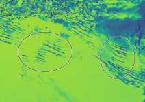
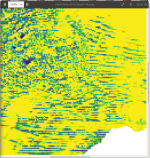
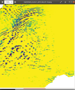
I'm seeing some strange patterns in the SWDDNI and SWDOWN variables, these patterns occur at various times and end up influencing the monthly averages. An example of the pattern can be seen in the following image, for the SWDOWN variable:

What could be leading to this?
These spots represent a marked decrease in irradiance compared to neighboring areas (more than 400 Wm^-2 in some cases) - the output is hourly.
Could it be the influence of cumulus clouds? Because these spots start to appear from midday... If so, isn't the feedback of these clouds on radiation very strong?
Thank you very much in advance,
Robson
I'm seeing some strange patterns in the SWDDNI and SWDOWN variables, these patterns occur at various times and end up influencing the monthly averages. An example of the pattern can be seen in the following image, for the SWDOWN variable:

What could be leading to this?
These spots represent a marked decrease in irradiance compared to neighboring areas (more than 400 Wm^-2 in some cases) - the output is hourly.
Could it be the influence of cumulus clouds? Because these spots start to appear from midday... If so, isn't the feedback of these clouds on radiation very strong?
Thank you very much in advance,
Robson


