Greetings,
I am seeing very unrealistic T2 (>315K in the winter) values primarily over LU_INDEX=16 grid cells mostly during the nighttime hours when using WRF version 4.3.0 with the following namelist.input settings:
&time_control
auxinput15_inname = 'wrfgeos_d<domain>',
auxinput15_outname = 'auxinput15_d<domain>_<date>',
auxinput15_interval = 60, 60, 60,
io_form_auxinput15 = 2,
&physics
aer_opt = 2,
aer_aod550_opt = 2, 2, 2,
aer_angexp_opt = 2, 2, 2,
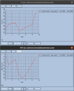
I am using time-varying aerosols from GEOS5 forecasts (wrfgeos_d<domain> files attached). I see no extreme aerosol AOD and ANG values in those files. T2 increases throughout the nighttime (see attached image) when it should be decreasing.
This does not happen when I use constant aerosols with the following namelist.input settings:
aer_opt = 2,
aer_aod550_opt = 1, 1, 1,
aer_aod550_val = 0.12,
aer_angexp_opt = 1, 1, 1,
aer_angexp_val = 1.3,
All other output appears to be fine (TSK, etc.), so the problem could be with how the diagnostic T2 is calculated within the NoahMP LSM.
I can provide the wrfgeos, wrfinput, wrfbdy, and other files upon request.
Thank you.
I am seeing very unrealistic T2 (>315K in the winter) values primarily over LU_INDEX=16 grid cells mostly during the nighttime hours when using WRF version 4.3.0 with the following namelist.input settings:
&time_control
auxinput15_inname = 'wrfgeos_d<domain>',
auxinput15_outname = 'auxinput15_d<domain>_<date>',
auxinput15_interval = 60, 60, 60,
io_form_auxinput15 = 2,
&physics
aer_opt = 2,
aer_aod550_opt = 2, 2, 2,
aer_angexp_opt = 2, 2, 2,
I am using time-varying aerosols from GEOS5 forecasts (wrfgeos_d<domain> files attached). I see no extreme aerosol AOD and ANG values in those files. T2 increases throughout the nighttime (see attached image) when it should be decreasing.
This does not happen when I use constant aerosols with the following namelist.input settings:
aer_opt = 2,
aer_aod550_opt = 1, 1, 1,
aer_aod550_val = 0.12,
aer_angexp_opt = 1, 1, 1,
aer_angexp_val = 1.3,
All other output appears to be fine (TSK, etc.), so the problem could be with how the diagnostic T2 is calculated within the NoahMP LSM.
I can provide the wrfgeos, wrfinput, wrfbdy, and other files upon request.
Thank you.