Liliputian_123
Member
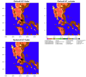
I have the following three experiments with modified USGS and inclusion of lake:
defaultLCLake ----default USGS with lake initialization, TAVGSFC included
defaultLC_nolake ----- default USGS without lake initialization, no TAVGSFC
UpdatedLC+Lake. ----- expanded urban with lake initialization, TAVGSFC included
I am getting weird results. The default land cover with lake and updated land cover with lake have the same results. Both are very far from the observed data.
I have the following questions:
[1] How can I plot TAVGSFC? Is it okay to use this file, which is daily, for hourly simulations?
[2] What Physics schemes directly affects surface temperature and relative humidity?
Any ideas what might be causing the large difference between the updated land cover and with lake compared to the observed? The time series below was extracted from a location to the north of the Lake (14.636002N, 121.077445E).
I have also attached all relevant files.
I'll appreciate any help on this.
---Lyndz