Hello,
I am trying to use a wrfvar_output to run a WRF forecast, and I have updated the WRF lateral boundary conditions. Then I run WRF with the new wrfinput(wrfvar_output) and the new wrfbdy_d01,but my forecast has discontinuities and poor results at the boundary. I don’t know what is wrong.
I do the test by following these steps:
1. Generate initial conditions for WRF(wrfinput) via WPS and real.exe
2. Run WRFDA on this wrfinput to assimilate observations and produce a wrfvar_output file
3. Run da_update_bc.exe to update the WRF lateral boundary conditions file created in step1(wrfbdy_d01),the input file is wrfvar_output and wrfbdy_d01
4. Run wrf.exe with the new wrfbdy_d01 and the new wrfinput(wrfvar_output) to produce a WRF forecast
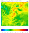
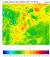
The result(figure 1,figure2) shows there is a obvious discontinuity at bounary.


The parame.in file is that:
&control_param
da_file = './wrfvar_output'
wrf_bdy_file = './wrfbdy_d01'
wrf_input = './wrfinput_d01'
domain_id = 1
cycling = .false.
debug = .true.
update_lateral_bdy = .true.
update_low_bdy = .false.
update_lsm = .false.
var4d_lbc = .false.
/
The domain is that:
&geogrid
parent_id = 1,
parent_grid_ratio = 1,
i_parent_start = 1,
j_parent_start = 1,
e_we = 400,
e_sn = 350,
geog_data_res = 'modis_30s_lake+5m',
dx = 5000,
dy = 5000,
map_proj = 'lambert',
ref_lat = 35,
ref_lon = 115,
truelat1 = 25.0,
truelat2 = 40.0,
stand_lon = 115,
Any suggestion will be appreciated!
I am trying to use a wrfvar_output to run a WRF forecast, and I have updated the WRF lateral boundary conditions. Then I run WRF with the new wrfinput(wrfvar_output) and the new wrfbdy_d01,but my forecast has discontinuities and poor results at the boundary. I don’t know what is wrong.
I do the test by following these steps:
1. Generate initial conditions for WRF(wrfinput) via WPS and real.exe
2. Run WRFDA on this wrfinput to assimilate observations and produce a wrfvar_output file
3. Run da_update_bc.exe to update the WRF lateral boundary conditions file created in step1(wrfbdy_d01),the input file is wrfvar_output and wrfbdy_d01
4. Run wrf.exe with the new wrfbdy_d01 and the new wrfinput(wrfvar_output) to produce a WRF forecast
The result(figure 1,figure2) shows there is a obvious discontinuity at bounary.


The parame.in file is that:
&control_param
da_file = './wrfvar_output'
wrf_bdy_file = './wrfbdy_d01'
wrf_input = './wrfinput_d01'
domain_id = 1
cycling = .false.
debug = .true.
update_lateral_bdy = .true.
update_low_bdy = .false.
update_lsm = .false.
var4d_lbc = .false.
/
The domain is that:
&geogrid
parent_id = 1,
parent_grid_ratio = 1,
i_parent_start = 1,
j_parent_start = 1,
e_we = 400,
e_sn = 350,
geog_data_res = 'modis_30s_lake+5m',
dx = 5000,
dy = 5000,
map_proj = 'lambert',
ref_lat = 35,
ref_lon = 115,
truelat1 = 25.0,
truelat2 = 40.0,
stand_lon = 115,
Any suggestion will be appreciated!
