Hello everyone,
Recently I have been trying to verify WRF model precipitation forecast with GOES RRQPE product (GOES RRQPE - Total Operational Weather Readiness - Satellites (TOWR-S) - Virtual Lab). However I haven't managed to achieve the same magnitude of precipitation.
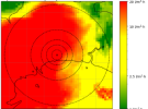
For example WRF looks like this:

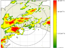
While RRQPE looks like this:

In theory, RRQPE data includes rainfall_rate in mm/h, available to download every 10 minutes. To achieve hourly accumulations (like WRF), we convert rainfall_rate to 10 minutes accumulation and sum for the hole hour.
Has anyone used this product? Does it really show surface precipitation? Or is it related to cloud potential water? Maybe I shouldn't be comparing them, but I don't really know what I'm missing.
Thanks for all the help.
Recently I have been trying to verify WRF model precipitation forecast with GOES RRQPE product (GOES RRQPE - Total Operational Weather Readiness - Satellites (TOWR-S) - Virtual Lab). However I haven't managed to achieve the same magnitude of precipitation.
For example WRF looks like this:

While RRQPE looks like this:

In theory, RRQPE data includes rainfall_rate in mm/h, available to download every 10 minutes. To achieve hourly accumulations (like WRF), we convert rainfall_rate to 10 minutes accumulation and sum for the hole hour.
Has anyone used this product? Does it really show surface precipitation? Or is it related to cloud potential water? Maybe I shouldn't be comparing them, but I don't really know what I'm missing.
Thanks for all the help.
