EliezerMayoral
New member
Hello everyone,
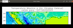
I am working with WRF UEMS and I am having an issue with the graphical outputs. The generated images appear incomplete or “cut off”. For example, in the plot of Maximum Temperature at 2m (°C) valid for 12Z15AUG2025, part of the domain is missing on the right side (especially over the Gulf of Mexico and the southeastern region).
In addition, I have noticed that all the generated images always show the same date (August 15), regardless of the cycle or run day.
When checking the output directory, I see that I am missing the .ctl, .grb2, and .idx files, and I suspect that could be the cause of the issue. However, I don’t know how to generate them or at what stage of the workflow they should be created. I also realized that I don’t have the namelist.input file, which makes me think that maybe the simulation is not even properly configured.
Has anyone experienced this situation before? Could the issue be related to the missing auxiliary files and the absence of namelist.input, or is it caused by another part of the WRF configuration/workflow?
Any guidance or recommendations would be greatly appreciated so I can resolve this and obtain complete images with the correct dates.
Thank you very much for your support!

