Scheduled Downtime
On Friday 21 April 2023 @ 5pm MT, this website will be down for maintenance and expected to return online the morning of 24 April 2023 at the latest

WRF4.4 vortex following domain option problem!

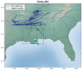
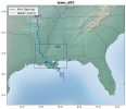
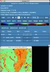
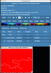
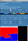
I am trying to reproduce some of the past hurricanes over the south-eastern USA (study area New Orleans, LA) and I am using WRF v4.4 vortex following option. However, some of the hurricane's track is not produced as they should be. The cindy.png image shows the track of hurricane Cindy (original vs plotting the lowest pressure from wrf_d02 output files). I cannot figure out why domain 2 moves that erratically and does not produce a similar storm track. This happened for several storms, whereas with the same parameters and options, some storms gave the expected result (such as Hurricane Isaac). I attached namelist.wps, namelist.input, and the figures.

Any help would be appreciated. Thanks!
 

Attachments

  • cindy.png
    cindy.png
    355.4 KB · Views: 19
  • isaac.png
    isaac.png
    338.5 KB · Views: 22
  • namelist.input.txt
    4 KB · Views: 15
  • namelist.wps.txt
    794 bytes · Views: 7
Hi,
Does there happen to be another area of low pressure at the same time that the vortex may be competing with? Vortex-following should follow the area of lowest pressure, but if the pressure of the vortex wasn't very low at the time of the simulation start, perhaps that's causing the issue? I see your plot says there was a 6-hour spin-up time. What happens if you use a longer spin-up - perhaps 12-24 hours?

I also did a 12-hr spin simulation and the result is similar for domain 2. But I didn't go beyond a 12-hr spin.
 

Attachments

  • cindy_slp_d02.png
    3.4 MB · Views: 5
Can you try using something like "ncview" to take a quick look at pressure. My concern is that there could be another area of low pressure that's in the domain and it's competing with the tropical low, which is why the track look erratic. While you're at it, you can use ncview to watch the storm progress over time. Is it tracking erratically like your plot is showing, or does it travel smoothly? If you aren't sure, you can share your wrfout files with me to take a look. They will probably be too large to attach to this forum, so if you have another way to share them, that will work. Otherwise, take a look at the home page of this forum for information on sharing large files. Thanks!
 
Can you try using something like "ncview" to take a quick look at pressure. My concern is that there could be another area of low pressure that's in the domain and it's competing with the tropical low, which is why the track look erratic. While you're at it, you can use ncview to watch the storm progress over time. Is it tracking erratically like your plot is showing, or does it travel smoothly? If you aren't sure, you can share your wrfout files with me to take a look. They will probably be too large to attach to this forum, so if you have another way to share them, that will work. Otherwise, take a look at the home page of this forum for information on sharing large files. Thanks!

Here is a link with all the output files for the 6-hr spin time. I am sorry but I do not know how to use ncview to check storm progress, so I am sending you the output files. Thanks!
 
Thanks for sending those. I took at look at your files and notice that something is wrong with your land mask, which should give values of 0 for water, and 1 for land. Your initial time is correct, but after that, it's mostly showing the entire domain as land. I notice the same with LU_INDEX (landuse type). Again, the initial time seems okay, but then it's a mess after that. I'm assuming there are several other things wrong, as well. I'm attaching a screenshot to show you. I've added the coastlines, which are shown by the dotted white line. I think you need to check your geo_em* and met_em* runs to make sure they look okay. If you'd like me to look at those output files, you can just point me to a download of the files. For met_em* files, I would only need the initial time and the next time.
 

Attachments

  • lu_index_01.png
    lu_index_01.png
    176.8 KB · Views: 20
  • lu_index_00.png
    lu_index_00.png
    163.4 KB · Views: 17
  • landmask_01.png
    landmask_01.png
    147.8 KB · Views: 11
  • landmask_00.png
    landmask_00.png
    149.2 KB · Views: 16
Thanks for sending those. I took at look at your files and notice that something is wrong with your land mask, which should give values of 0 for water, and 1 for land. Your initial time is correct, but after that, it's mostly showing the entire domain as land. I notice the same with LU_INDEX (landuse type). Again, the initial time seems okay, but then it's a mess after that. I'm assuming there are several other things wrong, as well. I'm attaching a screenshot to show you. I've added the coastlines, which are shown by the dotted white line. I think you need to check your geo_em* and met_em* runs to make sure they look okay. If you'd like me to look at those output files, you can just point me to a download of the files. For met_em* files, I would only need the initial time and the next time.


Thank you so much for your feedback. I attached geo_em and met_em files here (link).

My understanding of running the vortex option is that I do not need to produce geo_em and met_em files for domain 2 and we get domain 2 output after running wrf.exe. Now, as domain 2 is moving following the storm track when running real.exe and wrf.exe, I guess the landmask is supposed to change after some period (as the storm is going more inland). However, as the landmask changes to only land from the second time step, I think there are some issues and it will be great if you could take a look and provide me with some additional feedback.

Also, I forgot to mention before, I used ERA5 reanalysis data as the initial and boundary condition data. And, I attached namelist.wps and namelist.input files again.

Let me know if you need anything else. Thanks again.
 

Attachments

  • namelist.input.txt
    4 KB · Views: 9
  • namelist.wps.txt
    794 bytes · Views: 3
Hi,
Can you send the newest namelist.input file you're using for the geo_em and met_em files you sent? The one I have doesn't match the settings in the files, and since there are no d02 files (which is correct, as you stated above), I am not sure what d02 should be set to. Thanks!
 
Hi,
Can you send the newest namelist.input file you're using for the geo_em and met_em files you sent? The one I have doesn't match the settings in the files, and since there are no d02 files (which is correct, as you stated above), I am not sure what d02 should be set to. Thanks!


I am really sorry about the wrong files. I changed the namelist.wps and ran wrf with the new domain. Here is the link for new everything: Cindy_new.
Thanks!
 
Hi,
Thanks for sending those again. I'm waiting for them to download (it's taking a while), but something just occurred to me. Since you are using ERA5 data, you must also download an "invariant" file to process during WPS. Take a look at this FAQ that discusses how to do that. Based on your namelist.wps file, it doesn't appear that you did, so I'm curious if that is causing the issue. If you haven't already, can you try that and see if it makes any difference? Thanks!
Hi,

Thanks for the suggestion. I will try to run with ERA5-invariant asap. But, in the FAQ details, you mentioned using Vtable.ECMWF, but following this link Available GRIB Datasets from NCAR, I am using Vtable.ERA-interim_pl. Will that make any difference? Thanks!
 
Good question. I just compared the two Vtables, and it looks like they are identical except for text descriptions, so I don't believe it should make a difference which one you use.
 
Good question. I just compared the two Vtables, and it looks like they are identical except for text descriptions, so I don't believe it should make a difference which one you use.

Thanks! I am running with ERA5-invariant options currently. I will update you with the new results soon. Would you mind explaining a bit about what does this
ERA5-invariant options do?
 
That file contains some LANDSEA and Soil height information specific to the data.


Hello!

I apologize for the delay. I guess ERA5-invariant provided better track results for some of the storms. However, I had to discard using the vortex following option, as I found out that it was not the best option for my research. So, I went back to using normal wrf and now I am using WRF 4.4.2.
 
Top