Hi all,
I've updated the land use data of WRF using this dataset:https://cds.climate.copernicus.eu/cdsapp#!/dataset/satellite-land-cover?tab=overview
To do it, I used GDAL and convert_geotiff tools, and apparently everything went well (I am attaching the index file and a figure of my domain using the WRF default (with MODIFIED_IGBP_MODIS_NOAH) and the updating, as an illustration).
However, for some reason that I couldnt figure out yet, when I adopted the new configuration, the global attributes of my geogrid netcdf files assume the USGS mode (I am attaching the default and update nameltists, and what I got from the netcdf files). All the steps of wrf work fine, I also got the message 'SUCCESS COMPLETE WRF' from wrf.exe, however I would like to sort out this inconsistency.
Thank you in advance for your help
Attachments
-
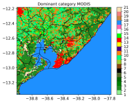 0MODIS_d03_landuse_salvador.png266.3 KB · Views: 986
 -
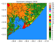 2018_d03_salvador.png258.4 KB · Views: 986
 -
index.txt426 bytes · Views: 69
-
namelist_new.wps931 bytes · Views: 66
-
namelist_default.wps898 bytes · Views: 62
-
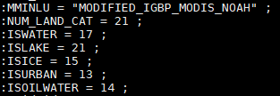 global_atributtes_default.PNG4.2 KB · Views: 986
 -
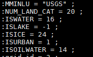 global_atributtes_new.PNG3.5 KB · Views: 986