Hello,
I’m looking to incorporate 1/3 arc second DEM data into WRF from national map database (https://apps.nationalmap.gov/downloader/#/). Specifically, from this website I used 1/3 arc-second DEM under Elevation Products (3DEP). I used the .tif file, then used gdal commands to convert into binary format, and changing filenames to respect the geogrid rules considering 00001-10812.00001-10812 etc.
The gdal command was something in this style:
gdal –of ENVI foo.fit temp.dat
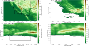
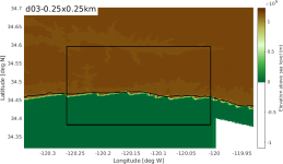
The projection works fine, but the values are in the order 10^9. See the 250 m domain (domain 3) in the attached figure. For reference, I also attached a figure that shows all desired domains, but using the standard 30s input domain. With some imagination I can see that using the 1/3 arc-second data the expected terrain elevation is present with a resolved valley. However, the values for terrain elevation are in the range of 10^9.
Using the .flt instead .tif and convert it to binary format gave similar results to what is posted here. I used some of the .hdr output to get some sense of the .tif file, and it shows that in the .tif data, the terrain elevation are in the expected value (0-1500 m). So, my conclusion was that either gdal conversion goes wrong, or my index file has wrong definitions. I’ve been looking into most options of the index file like endian, tile_bdr or word_size but that results in wrong projections, or even less normal values for terrain elevation.
I also looked into the convert_geotiff program that could produce the correct index file, but so far I have not been lucky to install this on the local machine.
Has anyone been successfull using this dataset? Or, perhaps if anyone has some kind of a hint to a solution that would be great.
Thanks for your help,
Gert-Jan


