
Dear WRF Support Team,
I am using WRF version 4.6.0 for wintertime simulations over complex mountainous terrain. One of the main problems is that the model does not reproduce nocturnal cold-air pools and valley inversions strongly enough. At several valley-floor stations, observed nighttime temperatures are several degrees colder than the simulated T2, while the model remains too warm during the night.
In my current setup, I use bl_pbl_physics = 2 (MYJ), sf_sfclay_physics = 2 (Eta Similarity), and sf_surface_physics = 4 (Noah-MP).
I would appreciate your advice on the following:
My main goal is to improve nighttime cooling, inversion strength, and cold-air accumulation at valley-floor locations.
Thank you very much for your advice.
I am using WRF version 4.6.0 for wintertime simulations over complex mountainous terrain. One of the main problems is that the model does not reproduce nocturnal cold-air pools and valley inversions strongly enough. At several valley-floor stations, observed nighttime temperatures are several degrees colder than the simulated T2, while the model remains too warm during the night.
In my current setup, I use bl_pbl_physics = 2 (MYJ), sf_sfclay_physics = 2 (Eta Similarity), and sf_surface_physics = 4 (Noah-MP).
I would appreciate your advice on the following:
- Horizontal resolution: My current innermost domain is about 1 km. I am considering reducing it to around 300 m and using a 30-m DEM. Is ~300 m sufficient for resolving cold-air drainage and valley cold pools, or would finer resolution be preferable?
- Vertical resolution: What height would you recommend for the first mass level above ground? Would around 10–15 m AGL be appropriate? Also, approximately how many vertical levels should be placed below 500 m and below 1 km? Is about 60–70 total eta levels reasonable?
- PBL scheme: Which PBL and surface-layer schemes are most suitable for stable nocturnal boundary layers, strong inversions, and cold-air pooling? I am currently testing MYJ + Eta similarity, but would MYNN or another option be more appropriate?
- 300-m gray zone: At approximately 300 m grid spacing, should a conventional PBL scheme still be used, or should a different turbulence treatment be considered?
- Other settings: Are there important settings related to horizontal diffusion, terrain smoothing, slope radiation, topographic shading, land-surface physics, or snow that are particularly important for valley cold-air pools?
- Nesting ratio: Is it acceptable to use parent-grid ratios of 3, 3, 5, or is 3, 3, 3 generally preferable? Could a ratio of 5 for the innermost domain cause problems with interpolation, numerical stability, two-way nesting, or terrain-induced circulations?
My main goal is to improve nighttime cooling, inversion strength, and cold-air accumulation at valley-floor locations.
Thank you very much for your advice.
Attachments
-
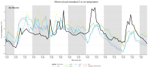 Ala (Ronchi).png968.8 KB · Views: 1
 -
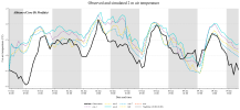 Albiano (Cave Di Porfido).png941.7 KB · Views: 1
 -
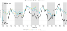 Aldeno (San Zeno).png952.1 KB · Views: 1
 -
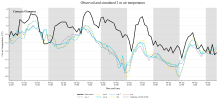 Canazei (Ciampac).png914.4 KB · Views: 1
 -
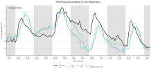 Canazei (Gries).png967.9 KB · Views: 1
 -
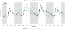 Caoria.png881.4 KB · Views: 1
 -
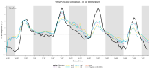 Cavalese.png849.4 KB · Views: 0
 -
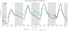 Cembra.png889.9 KB · Views: 0
 -
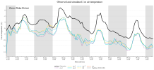 Daone (Malga Bissina).png888.5 KB · Views: 0
 -
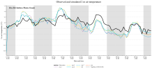 Dos Del Sabion (Monte Grual).png836.6 KB · Views: 1