Scheduled Downtime
On Friday 21 April 2023 @ 5pm MT, this website will be down for maintenance and expected to return online the morning of 24 April 2023 at the latest

Altering MPAS's initial conditions

lamizha

New member
I have read previous discussions about altering WRF's initial conditions: Altering WRF's initial conditions, and the replies for the WRF model are very helpful. I am wondering if changing intermediate files obtained from WPS is the best way to alter MPAS' initial conditions. If yes, how can I change variables from those intermediate files, which are not regular netcdf files? Thanks!
 
If this is a global MPAS run, I would say it is better to change mpas initial data. This is because the initial data is netCDF format, which is much easier to manipulate.

For regional MPAS run, it is possible that you need to change both initial and boundary data. Hence it is better to modify the intermediate files. You may need to create a fortran code or a python script to read the data, change the value of some variables, then write it back to intermediate format.
Hi Ming,

Thanks for your suggestion. I am now considering changing initial conditions for the global MPAS run (60-3km mesh). Do you have any idea about the approximate spin-up time for changing different initial variables? For non-change run, I will spin up for about 6 hours and timestep is about 15 seconds. If I change the vegation type (say vegetation fraction), do I need to increase my spin-up time, e.g., a few hours more or even several days?

Thanks!
 
Hi,
Based on our experience with WRF model, 9-12 hours of spin-up time is sufficient. Note that WRF is a limited-area model under constraints of large scale forcing. The spin-up time for MPAS global model could be different. A few papers have mentioned the spin-up issue for MPAS. For example, the spin-up time is set to 24h in the study https://macmaq.aqrc.ucdavis.edu/sites/g/files/dgvnsk6036/files/inline-files/Kemal Gurer_Poster.pdf.
Please refer to the literature for more information.
Hi Ming,

Thanks for your suggestions. I try to alter some variables in the init.nc file, such as terrain height (ter) and vegetation fraction (vegfra), over a selected domain by multiplying a factor (e.g., x 2.0 or x 0.5). After changing the two variables and running the model, the model outputs do not change at all (I am running 60-3km resolution and dt = 15 seconds) compared to the run without changing any initial conditions. However, when I change atmospheric variables, such as horizontal normal velocity at edges (u) and water vapor mixing ratio (qv), the model outputs truly change compared to the run without changing any initial conditions.

I am confused why changing the terrain height and vegetation fraction does not lead to a change in model outputs (e.g., 2m temperature). I am wondering if I did anything wrong and if there is any better way to modify the terrain height and vegetation fraction so I can measure how the change in the two variables may influence the outputs.

Thank you!
 
Did you save "vegfra" and "ter" In your history output file? if so, can you compare the two variables before and after your modification and let me know whether they are different. Thanks.
 
Did you save "vegfra" and "ter" In your history output file? if so, can you compare the two variables before and after your modification and let me know whether they are different. Thanks.
Hi Ming,

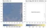
For terrain height (ter), I found a strange thing no matter whether I change the "ter" in the init.nc file or not. Fig. 1a shows the ter for the init.nc, which is the narmal terrain height over Eq. Africa. However, the ter in diag.nc file for the initial time (which is 18:00) becomes zero (Fig. 1b), so do the following diag.nc files (e.g., 18:05, 18:10, etc).
1691627572699.png

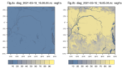
For vegetation fraction (vegfra), the output is also strange. For the simulation I multiple a factor of 0.2 to vegfra, the diag.nc file at initial time (18:00) (Fig. 2a) truly reflects my change in init.nc (i.e., vegfra over Eq. Africa ~15). However, the vegfra in the following timesteps (e.g., 18:05, Fig. 2b) changes back to the value without any modification (i.e., vegfra over Eq. Africa ~90).
1691628764004.png
I am confused why ter is zero in diag.nc file (as well as in history.nc file) and why vegfra changes back to its original value after the initial timestep.

Thank you!
 
Please confirm that you change 'ter' and 'vegfra' in your init.nc.

ter and vegfra will remain unchanged in history and dig files. They are always the same as in init.nc ( suppose you didn't run with sst_update).
 
Please confirm that you change 'ter' and 'vegfra' in your init.nc.

ter and vegfra will remain unchanged in history and dig files. They are always the same as in init.nc ( suppose you didn't run with sst_update).
Hi Ming,

Thanks for your response. I confirm that I change ter and vegfra in the init.nc.

I find that "ter" is always ZERO over the globe when I draw "ter" in history.nc and diag.nc files. I tried both 60-3km resolution and 240-48km resolution in the MPAS tutorial no matter "ter" is changed or not in the init.nc file. For the namelist and streams, they are exactly the same as our tutorial for the 240-48km resolution run (attached below).

Could you please try with the 240-48km resolution as our tutorial to see if "ter" is always zero in the output file in your convenience?

1691954095121.png
Thank you!
 

Attachments

  • namelist.atmosphere.txt
    1.7 KB · Views: 2
  • stream_list.atmosphere.diagnostics.txt
    1.2 KB · Views: 0
  • streams.atmosphere.txt
    1.5 KB · Views: 1
"ter' is terrain height in MPAS and it cannot be zero everywhere. I looked at this variable in various meshes, and it is reasonable, not 'zero' everywhere.

Can you look at this variable in your static data and init.nc? I guess it is zero in these two datafile. This indicates that something went wrong at the state when you create static data and initial. condition.

If so, we need to start from the beginning to rerun init_atmopshere.
 
Top