I noticed that there is a slight shift in the terrain in SRTM_topo_3s. I am using the
database on cheyenne:
/glade/work/wrfhelp/WPS_GEOG
I assume it's in the repo too.
I found that the index file should be as follows to make things right.
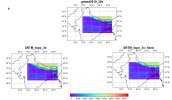
You can see the attached figure as proof. The terrain is shifted south
of Nepal in the SRTM_topo_3s which is not in the 30s terrain.
type = continuous
signed = yes
projection = regular_ll
dx = 0.00083333
dy = 0.00083333
known_x = 1.0
known_y = 1.0
known_lat = -54.99916667
known_lon = -178.99916667
wordsize = 2
tile_x = 1200
tile_y = 1200
tile_z = 1
tile_bdr = 0
units = "meters MSL"
filename_digits = 6
description = "SRTM v3 3-arc-second averaged data"
database on cheyenne:
/glade/work/wrfhelp/WPS_GEOG
I assume it's in the repo too.
I found that the index file should be as follows to make things right.
You can see the attached figure as proof. The terrain is shifted south
of Nepal in the SRTM_topo_3s which is not in the 30s terrain.
type = continuous
signed = yes
projection = regular_ll
dx = 0.00083333
dy = 0.00083333
known_x = 1.0
known_y = 1.0
known_lat = -54.99916667
known_lon = -178.99916667
wordsize = 2
tile_x = 1200
tile_y = 1200
tile_z = 1
tile_bdr = 0
units = "meters MSL"
filename_digits = 6
description = "SRTM v3 3-arc-second averaged data"