You are using an out of date browser. It may not display this or other websites correctly.
You should upgrade or use an alternative browser.
You should upgrade or use an alternative browser.
computing model height/thickness
- Thread starter madhavhmk
- Start date
This post was from a previous version of the WRF&MPAS-A Support Forum. New replies have been disabled and if you have follow up questions related to this post, then please start a new thread from the forum home page.
Hi,
This value can differ because thickness varies at each point due to the model being terrain-following.
(PHB + PH)/g gives geopotential on each model (vertical) level.
Then you will need to find geopotential above and below that to obtain thickness, at each grid point.
Just to note: geopotential and velocity are on full levels. All other variables are on half levels.
Hi,
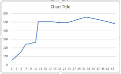
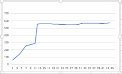
No, that is way too high to be reasonable. The thickness will certainly vary, and will increase with height for a while, but you shouldn't be seeing anything above 1km per layer. I'm attaching a plot showing what I've calculated for a basic run, over a water location, and then one over higher altitude. I used 45 levels for this run.
Kelly