Scheduled Downtime
On Friday 21 April 2023 @ 5pm MT, this website will be down for maintenance and expected to return online the morning of 24 April 2023 at the latest

Couldn't find a suitable Vtable for RRFS prslev conus 3 km data

chengbin0228

New member
I'm trying to run WRF with RRFS input data (https://noaa-rrfs-pds.s3.amazonaws.com/index.html#rrfs_a/) processed through WPS using an existing Vtable. I have tried Vtable. raphrrr; Vtable.NAM; Vtable.RAP.pressure.ncep), but none of them realy worked. The ungrid.exe was done successfully, but metgrid.exe never worked. I've included the logs when I run WPS using Vtable.raphrrr.
 

Attachments

  • metgrid.hour.h00.log
    410 bytes · Views: 0
  • metgrid.log
    48.8 KB · Views: 1
  • ungrib_nam.log
    557.4 KB · Views: 0
  • ungrib.log
    667.4 KB · Views: 0
At the end of your metgrid.log, the following error messages showed up:

2025-08-25 17:44:21.106 --- WARNING: Field PRES has missing values at level 200100 at (i,j)=(1,1)


2025-08-25 17:44:21.263 --- WARNING: Field GHT has missing values at level 200100 at (i,j)=(1,1)


2025-08-25 17:44:21.291 --- WARNING: Field SOILHGT has missing values at level 200100 at (i,j)=(1,1)


2025-08-25 17:44:21.305 --- WARNING: Field PSFC has missing values at level 200100 at (i,j)=(1,1)

This indicates that your wrf domain is beyond the area covered by RRFS. Can you adjust your domain and try again?
 
Hi Ming,

I tried to download rrfs.t00z.prslev.3km.f***.na.grib2 instead of rrfs.t00z.prslev.3km.f***.conus.grib2 for my simulation domain, this time the ungrid.exe is not working at all. You can find my namelist.wps ungrib.log ungrib_nam.log files attached.
1756496504888.png
 

Attachments

  • ungrib_nam.log
    285 bytes · Views: 1
  • ungrib.log
    904 bytes · Views: 1
  • namelist.wps
    1.1 KB · Views: 0
Your log file indicates that the map projection of your input data is not recognized by ungrib.

Can you check the detailed structure of your data, especially its projection, spatial coverage, GRIB parameters, etc.?
 
Hi Ming,

I believe that the ungrib.exe is unable to read the rrfs.t00z.natlev.3km.f000.na.gib2 file, which covers the North America domain. Therefore, I downloaded the rrfs.t00z.prslev.3km.f000.conus file instead.gib2 file, which only covers the US CONUS domain. Now, I'm trying to run WPS with a domain smaller than 12US2 (shown below). The geogrid.exe and ungrib.exe both work fine, but the metgrid.exe can't be executed, and I attached the log report. BTW, I'm using Vtable.raphrrr, do you think this has anything to do with the metgrib.exe crash?

Thanks,
Bin Cheng
1756920312473.png
 

Attachments

  • metgrid.log
    15.4 KB · Views: 1
Hi Bin,

Can you check

(1) what is the map projection used in rrfs.t00z.natlev.3km.f000.na.gib2 and rrfs.t00z.prslev.3km.f000.conus?

(2) Does the data rrfs.t00z.prslev.3km.f000.conus cover the same area as that of rrfs.t00z.natlev.3km.f000.na.gib2?

(3) What is the difference in grid structure between HRRR and RRFS?

I remember that HRRR used rotated lat-lon grid, but not sure of the grid structure for RRFS. WPS doesn't provide Vtable for RRFS. If the grid structure/variable parameters are different between RRFS and HRRR, then the use of Vtable.raphrrr could cause issues.
 
Hi Ming,

(1). Map projection used in rrfs.t00z.natlev.3km.f000.na.gib2 is
25:128014299:grid_template=1:winds(N/S):
rotated lat-lon grid:(4881 x 2961) units 1e-06 input WE:SN output WE:SN res 48
lat -37.000000 to 37.000000 by 0.025000
lon 299.000000 to 61.000000 by 0.025000 #points=14452641
south pole lat=-35.000000 lon=247.000000 angle of rot=0.000000
Map projection used in rrfs.t00z.prslev.3km.f000.conus.grib2 is
707:638982124:grid_template=30:winds(grid):
Lambert Conformal: (1799 x 1059) input WE:SN output WE:SN res 56
Lat1 21.138123 Lon1 237.280472 LoV 262.500000
LatD 38.500000 Latin1 38.500000 Latin2 38.500000
LatSP -90.000000 LonSP 0.000000
North Pole (1799 x 1059) Dx 3000.000000 m Dy 3000.000000 m
(2). No, I believe rrfs.t00z.natlev.3km.f000.na.gib2 covers a larger domain than rrfs.t00z.prslev.3km.f000.conus.grib2. For example na stands for North American, conus stands for Contiguous U.S..
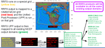
1756923105841.png
(3). I don't have all the details, below is the summary from ChatGPT.
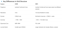
1756923341722.png
If Vtable.raphrrr is not the right Vtable, will there be a existing Vtable that I can use now?

Thanks,
Bin Cheng
 
Hi Bin,

Thanks for the figuring out these critical information. It is clear that RRFS data are outputs from regional FV3, whereas HRRR are outputs of WRF.

Sorry that we don't have Vtable for FV3 outputs.

Please tell me where you download RRFS data, I will take a look and get back to you if I can figure out how to process the data.
 
Top