Jinlong Ma
New member
Dear all wrf users,
I wanted to use new MODIS land use data in WPS and replace it with WPS default land use data. I followed the steps listing in the post of meteors(
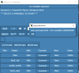
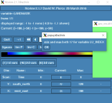
The geogrid.exe program worked successfully, but the result of LANDINDEX and LANDMASK was none.


The minimum and maximum of the landindex both are 17, and the minimum and maximum of the landmask both are -1, I can't find the wrong place.
Note: The MODIS raster file spatially covers the domain 01.
The dates are available in the below:
View attachment test_modis.zip
Any suggestions or ideas would be appreciated.
I wanted to use new MODIS land use data in WPS and replace it with WPS default land use data. I followed the steps listing in the post of meteors(
). I chose the domain of china as the study area, and I was sure the download domain is large than Chinese domain(197x127,36km).But I met a problem here, I don't know how to make sure the known_lat and known_lon in the index file, where can I find out the information? I just used the latitude and longitude of the output of WPS(met_*).How to replace MODIS Land Use data in WPS
The geogrid.exe program worked successfully, but the result of LANDINDEX and LANDMASK was none.


The minimum and maximum of the landindex both are 17, and the minimum and maximum of the landmask both are -1, I can't find the wrong place.
Note: The MODIS raster file spatially covers the domain 01.
The dates are available in the below:
View attachment test_modis.zip
Any suggestions or ideas would be appreciated.
