Dear WRF Community,
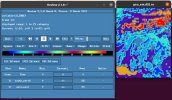
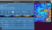
I'm using WPS-4.3.1 version and 2 domains. Mother domain - 15000, nested - 5000. I chose USGS 30 arc-second classification land cover data over my domain, so in namelist.wps my geog_data_res = 'usgs_30s', 'usgs_30s'. When running ./gegorid.exe, it successfully generates two geogrid files - geo_emd01.nc and geo_emd02.nc. When trying to visualize LU_INDEX parameter using ncview command, geo_emd01.nc scale has 24 land categories, while geo_emd02.nc scale shows only 21 land categories (I attached the photos). What's the reason? Is it because in my nested domain some land classes are not present? but still, the scale should depict all 24 classes, no?
Then I checked my geogrid.log, and saw some warning messages like:
INFORM: For HGT_M, couldn't find interpolator sequence for resolution usgs_30s.
2023-04-16 17:54:39.623 --- INFORM: Using default interpolator sequence for HGT_M.
2023-04-16 17:54:39.623 --- INFORM: For HGT_M, couldn't find usgs_30s data source.
2023-04-16 17:54:39.623 --- INFORM: Using default data source for HGT_M.
2023-04-16 17:54:39.623 --- INFORM: Using usgs_30s interpolator sequence for LANDUSEF.
2023-04-16 17:54:39.623 --- INFORM: Using usgs_30s data source for LANDUSEF.
2023-04-16 17:54:39.623 --- INFORM: For SOILTEMP, couldn't find interpolator sequence for resolution usgs_30s.
There's no LU_INDEX parameter, but what does "For HGT_M, couldn't find usgs_30s data source, Using default interpolator sequence for HGT_M." mean? Is the geogrid.exe using default MODIS elevation data for the HGT_M elevation parameter?
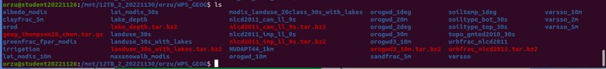
I attached my namelist.wps, both geogrid files and geogrid.log. As for static data, I downloaded "High resolution of each mandatory field" and some optional fields like "urbfrac, lakes_depth, clayfrac, irrigation, and etc". Also attached the screenshot of my WPS_GEOG.
I would appreciate if you could answer to my questions,
Orzu
I'm using WPS-4.3.1 version and 2 domains. Mother domain - 15000, nested - 5000. I chose USGS 30 arc-second classification land cover data over my domain, so in namelist.wps my geog_data_res = 'usgs_30s', 'usgs_30s'. When running ./gegorid.exe, it successfully generates two geogrid files - geo_emd01.nc and geo_emd02.nc. When trying to visualize LU_INDEX parameter using ncview command, geo_emd01.nc scale has 24 land categories, while geo_emd02.nc scale shows only 21 land categories (I attached the photos). What's the reason? Is it because in my nested domain some land classes are not present? but still, the scale should depict all 24 classes, no?
Then I checked my geogrid.log, and saw some warning messages like:
INFORM: For HGT_M, couldn't find interpolator sequence for resolution usgs_30s.
2023-04-16 17:54:39.623 --- INFORM: Using default interpolator sequence for HGT_M.
2023-04-16 17:54:39.623 --- INFORM: For HGT_M, couldn't find usgs_30s data source.
2023-04-16 17:54:39.623 --- INFORM: Using default data source for HGT_M.
2023-04-16 17:54:39.623 --- INFORM: Using usgs_30s interpolator sequence for LANDUSEF.
2023-04-16 17:54:39.623 --- INFORM: Using usgs_30s data source for LANDUSEF.
2023-04-16 17:54:39.623 --- INFORM: For SOILTEMP, couldn't find interpolator sequence for resolution usgs_30s.
There's no LU_INDEX parameter, but what does "For HGT_M, couldn't find usgs_30s data source, Using default interpolator sequence for HGT_M." mean? Is the geogrid.exe using default MODIS elevation data for the HGT_M elevation parameter?
I attached my namelist.wps, both geogrid files and geogrid.log. As for static data, I downloaded "High resolution of each mandatory field" and some optional fields like "urbfrac, lakes_depth, clayfrac, irrigation, and etc". Also attached the screenshot of my WPS_GEOG.
I would appreciate if you could answer to my questions,
Orzu
Attachments
Last edited: