srinivasmet
New member
Hi friends,
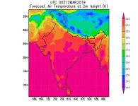
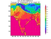
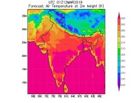
I have run WRF model with GFS data to generate real time operational forecast over Indian region. But from the output what I understand that is, model producing very high contrast values for most of the parameters like temperature, fluxes etc. over land areas adjoining to the coast except from initial time step. For experimental purpose I have run WRF model with FNL data for the same period, where I don't have this issue.
can anyone please suggest me why it is happening and how can resolve this issue. Here with I am send near surface air temperature images for your reference.Thanks in advance
with best regards from
Srinivas