hannahv1711
New member
Hi,
I recently experienced that WRF did not run on the input files that I had generated by running real.
After checking the met_em files I discovered that I had no data in the SST and SEAICE variables.
I later found out that I had defined the wrong geo information for these data when making the intermediate files using pywinter (documentation: pywinter — pywinter 2.0.6 documentation).
The first time I produced the intermediate files I had assumed a cylindrical equidistant grid instead of the gaussian grid.
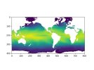
In the geo information for the Gaussian grid one must give the southwest corner latitude and longitude for the data. In this instance, I get the values -78.67, 82.85 for the latitude and longitude respectively. I attach a quick plot of one of the data files.
The problem is that when I try to run metgrid on the files with the correct (gaussian) grid defined, I encounter an error message:
Processing 1980-01-01_06
FILE
Oops, something is not right with the Gaussian latitude computation.
The input data gave the starting latitude as -78.675.
This routine computed the starting latitude as +- 89.661.
The difference is larger than 0.01 degrees, which is not expected.
ERROR: Gaussian_latitude_computation
--------------------------------------------------------------------------
Here it seems that the latitude of the corner is not as expected by metgrid, even though this is indeed the latitude of data point.
How do I fix this in order to get metgrid to run again?
Thanks in advance for any tips!
I recently experienced that WRF did not run on the input files that I had generated by running real.
After checking the met_em files I discovered that I had no data in the SST and SEAICE variables.
I later found out that I had defined the wrong geo information for these data when making the intermediate files using pywinter (documentation: pywinter — pywinter 2.0.6 documentation).
The first time I produced the intermediate files I had assumed a cylindrical equidistant grid instead of the gaussian grid.
In the geo information for the Gaussian grid one must give the southwest corner latitude and longitude for the data. In this instance, I get the values -78.67, 82.85 for the latitude and longitude respectively. I attach a quick plot of one of the data files.
The problem is that when I try to run metgrid on the files with the correct (gaussian) grid defined, I encounter an error message:
Processing 1980-01-01_06
FILE
Oops, something is not right with the Gaussian latitude computation.
The input data gave the starting latitude as -78.675.
This routine computed the starting latitude as +- 89.661.
The difference is larger than 0.01 degrees, which is not expected.
ERROR: Gaussian_latitude_computation
--------------------------------------------------------------------------
Here it seems that the latitude of the corner is not as expected by metgrid, even though this is indeed the latitude of data point.
How do I fix this in order to get metgrid to run again?
Thanks in advance for any tips!